Tennessee State Route 79
State Route 79 (SR 79) is a 10.37-mile-long (16.69 km) state highway in southwestern Lake County, Tennessee. SR 79 has a dual primary and secondary designation[2] and is one of a few state routes in Tennessee to have an aggregate (gravel) road surface.
| ||||
|---|---|---|---|---|
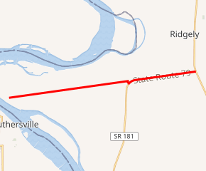
SR 79 highlighted in red | ||||
| Route information | ||||
| Maintained by TDOT | ||||
| Length | 10.37 mi[1] (16.69 km) | |||
| Existed | 1947–present | |||
| Major junctions | ||||
| West end | Dead end at Mississippi River at Hathaway | |||
| East end | ||||
| Location | ||||
| Counties | Lake | |||
| Highway system | ||||
| ||||


Route description
The western terminus of SR 79 is located at the Mississippi River (Island 15) in the extreme southwestern portion of Lake County, Tennessee and travels across low-lying areas that are subject to flooding from the Mississippi River. SR 79 from its western terminus (mile 0.00) to mile 6.66 has been repeatedly damaged by seasonal flooding and as a result TDOT uses gravel, crushed stone, sand and dirt to rebuild the road surface when it has been damaged from flooding. This section is unsigned in the field. At mile 6.66, SR 79 crosses the federal levee to its eastern terminus near Ridgely, Tennessee.
History
SR 79 was known as Powell Ferry Road prior to its designation as a state route and served the Powell Ferry (also known as the Pemiscot Ferry) that crossed the Mississippi River to Caruthersville, Missouri. This ferry began service in 1895 and was operated by Lee Line Steamers.[3] The roadway geometry of SR 79 has been changed very little since its designation as a state highway with the only major change being at the junction of SR 79 and SR 181.[4]
Major intersections
The entire route is in Lake County.
| Location | mi[5] | km | Destinations | Notes | |
|---|---|---|---|---|---|
| Hathaway | 0.0 | 0.0 | Dead end at Mississippi River | Western terminus; SR 79 begins as an unsigned secondary highway | |
| | 6.6 | 10.6 | SR 79 becomes a signed primary highway; northern terminus of SR 181 | ||
| | 10.3 | 16.6 | Eastern terminus; SR 79 ends as a primary highway; provides access to Reelfoot Lake State Park and Reelfoot National Wildlife Refuge | ||
| 1.000 mi = 1.609 km; 1.000 km = 0.621 mi | |||||
References
- TDOT Region 4 Pavement Condition Data
- Tennessee Department of Transportation County Maps and City Maps
- Rootsweb MOGENWEB, 1904 Pemiscot County
- Aerial photo of SR 79 & SR 181 intersection from USGS via Microsoft Research Maps
- retrieved from DeLorme Street Atlas USA