Tartar (river)
The Tartar (Azerbaijani: Tərtərçay, Armenian: Թարթառ) is one of the tributaries of the Kura River. It is de jure located in central part of Republic of Azerbaijan, though most of the area where it flows is de facto part of the unrecognized Nagorno-Karabakh Republic.
| Tartarchay Tartar, Թարթառ | |
|---|---|
 | |
| Native name | Tərtərçay |
| Location | |
| Country | Azerbaijan (de jure), Nagorno-Karabakh Republic(de facto) |
| Region | Caucasus |
| District | Kalbajar, Barda, Tartar (Azerbaijan) Shahumian, Martakert (NKR) |
| Cities | Kelbajar, Agdara (Azerbaijan) Martakert (NKR), Tartar, Barda |
| Physical characteristics | |
| Source | Lesser Caucasus |
| • location | Near İstisu, Kalbajar, Kalbajar Rayon, Azerbaijan (de jure), Martakert region of NKR(de facto) |
| • coordinates | 39°55′56″N 45°58′6″E |
| • elevation | 3,120 m (10,240 ft)[1] |
| Mouth | Kura River |
• location | Barda, Azerbaijan |
• coordinates | 40°26′49″N 47°18′26″E |
| Length | 200 km (120 mi)[1] |
| Basin size | 2,650 km2 (1,020 sq mi)[1] |
| Discharge | |
| • location | directly downstream into Kura[1] |
| • average | 22 m3/s (780 cu ft/s)[1] |
| Basin features | |
| River system | Kura River |
| Tributaries | |
| • left | Levçay, Ağdabançay |
| • right | Turağayçay |
Overview

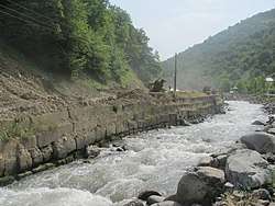
Tartar is the left tributary of Kura, the largest river in Caucasus. The river originates in the area where Qonqur, Alaköz and Mıxtökən mountain ranges meet on Karabakh Plateau in the vicinity of hot springs village of Istisu located de jure in Kalbajar Rayon of Azerbaijan[2] and de facto in Martakert Province of Nagorno-Karabakh Republic. The altitude where the river originates from mountain springs is 3,120 m (10,240 ft) above sea level. The river flows eastward through the whole Kalbajar rayon (de facto Martakert Province) passing through Kalbajar city, Tartar and Barda raions passing through Tartar and Barda cities before discharging into Kura. The river has two left Levçay. (36 km (22 mi)) and Ağdabançay (19 km (12 mi)), and one right Turağayçay (35 km (22 mi)) tributaries. Sarsang reservoir was built on Tartar river in 1976 for electricity and irrigation purposes.[1]
Statistical information
The overall length of the river is 200 km (120 mi), the basin area is 2,650 km2 (1,020 sq mi). Tartarchay is considered one of the water-rich tributaries of Kura within Azerbaijani territory. The water volumes are sourced from rainfall (14%), snow (28%) and underground waters (58%). During spring and summer months, the snow melting in the mountains causes floods making up 65-70% of the annual water flow. In August and September, the water levels decrease. From October until November, the rainfall increases the water levels again. The average annual discharge of the river is 22 m3/s (780 cu ft/s). Average annual flow is 693.8 million m3. The average mineralization of the river is 300-500 mg/l with hydrocarbons and calcium.[1]
Water uses
What was once the famous resort village of Istisu (meaning "Hot Water" in Azerbaijani), which was ruined in the Nagorno Karabakh War, is located on the lower part of the river. The resort contains both natural drinking mineral water and hot water spring for bathing. Most of the area where the river flows is now part of de facto independent Nagorno-Karabakh Republic. Sarsang Hydro Power Plant with capacity of 50 megawatt is operated at the Sarsang reservoir of the river[3] and is the main source of electric energy for Nagorno-Karabakh Republic (40-60%).[4]
See also
- Rivers and lakes in Azerbaijan
- Qarqar River
References
- RIVERS OF AZERBAIJAN: Tərtərçay
- Ministry of Ecology: Azərbaycanın çayları, gölləri və su anbarları Archived 2014-10-17 at the Wayback Machine Retrieved on 15 October
- Artsakh HEK and ArmenBrok. "IPO Investment Memorandum" (PDF). Armenbrok CJSC. Archived from the original (PDF) on July 7, 2011. Retrieved January 12, 2011.
- Mediamax (2009-03-03). ""Artsakh Hydroelectric Power Plant" realizes the first IPO in Armenia". Banks.am. Retrieved 9 January 2011.
| Wikimedia Commons has media related to Tartar river. |
| Major rivers | |
|---|---|
| Major lakes | |
| Major reservoirs |
|