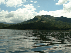
Tapo-Caparo National Park
The Tapo-Caparo National Park[1] (Spanish: Parque nacional Tapo-Caparo)[2] Also National Park Tapo Caparo Is a protected area with the national park[3] status in Venezuela,[4] which covers an area estimated at 2,050 square kilometers and is administratively located between the states of Barinas, Mérida and Táchira, to the west of Venezuelan territory. National park was decreed The 14 of January 1992 in the government of the then president Carlos Andrés Pérez.
| Tapo-Caparo National Park Parque nacional Tapo-Caparo | |
|---|---|
IUCN category II (national park) | |
 | |
.jpg) Location | |
| Location | |
| Coordinates | 8°08′N 71°08′W |
| Area | 2,050 km2 (790 sq mi) |
| Established | 1992 |
It has a diversity of forests, ferns and mosses, lichens, fungi, fauna that includes jaguars, toucans, boas and numerous gorges and rivers, was created with the purpose of protecting the nature near a dam called Uribante-Caparo hydroelectric complex.
References
- Parque nacional Tapo-Caparo
- Guía ecoturística de Venezuela (in Spanish). Miro Popić Editor C.A. 1998-01-01.
- Weidmann, K. (2003-01-01). Parques nacionales de Venezuela (in Spanish). Oscar Todtmann.
- Boyla, Kerem; Estrada, Angélica; International, BirdLife (2017-03-10). Áreas importantes para la conservación de las aves en los Andes tropicales: sitios prioritarios para la conservación de la biodiversidad (in Spanish). BirdLife International. ISBN 9789978441961.
This article is issued from Wikipedia. The text is licensed under Creative Commons - Attribution - Sharealike. Additional terms may apply for the media files.