Tanyurer
The Tanyurer (Russian: Танюрер) is a river in Chukotka in Russia, a left tributary of the Anadyr. The length of the river is 482 kilometres (300 mi). The area of its drainage basin is 18,500 square kilometres (7,100 sq mi).[1]
| Tanyurer | |
|---|---|
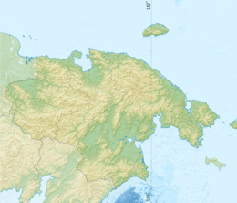 Location of the mouth in the Chukotka Autonomous Okrug, Russia | |
| Location | |
| Country | Russia |
| Federal subject | Chukotka Autonomous Okrug |
| Physical characteristics | |
| Source | |
| • location | Pekulney Range |
| • coordinates | 67°32′4″N 177°23′29″E |
| Mouth | |
• location | Anadyr |
• coordinates | 64°44′10″N 174°18′43″E |
• elevation | 1 m (3 ft 3 in) |
| Length | 482 km (300 mi) |
| Basin size | 18,500 km2 (7,100 sq mi) |
| Basin features | |
| Progression | Anadyr→ Bering Sea |
Course
It flows roughly southwards from the Pekulney Range of the Chukotka Mountains and passes through the sparsely populated areas of Chukotka. This river meets the Anadyr in the lower stretch of its course, being the last large tributary of the Anadyr.[2]
The whole basin of the Tanyurer and its tributaries belong to the Chukotka Autonomous Okrug.
See also
References
- Russian State Water Register - Tanyurer River
- Танюрер, Great Soviet Encyclopedia in 30 vols. / Ch. ed. A.M. Prokhorov - 3rd ed. - M, 1969-1978. (in Russian)
This article is issued from Wikipedia. The text is licensed under Creative Commons - Attribution - Sharealike. Additional terms may apply for the media files.