Tanah Jambu
Tanah Jambu is a settlement in the northeastern part of Brunei-Muara District, Brunei. It is officially a village subdivision of Mentiri, a mukim (subdistrict) of the district. Tanah Jambu comprises the original village settlement, as well as the Tanah Jambu public housing estates of Landless Indigenous Citizens' Housing Scheme and National Housing Scheme.[1][2][3] The postcode for Tanah Jambu is BU1129.[4][5]
Tanah Jambu | |
|---|---|
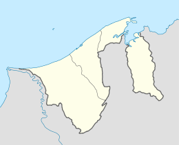 Location in Brunei | |
| Coordinates: 4°59′49″N 115°00′11″E | |
| Country | Brunei |
| District | Brunei-Muara |
| Mukim | Mentiri |
| Postcode | BU1129 |
Name
As a village subdivision, Tanah Jambu is officially known in Malay as Kampung Tanah Jambu (Kampung is sometimes spelt as Kampong),[4] which literally means 'Tanah Jambu Village'.
References
- "Sultanate - News | Negara Brunei Darussalam | His Majesty visits Meragang, Kg Tanah Jambu housing schemes". www.sultanate.com. Retrieved 2018-04-18.
- "News - Water Supply Disruption". www.rtbnews.rtb.gov.bn. Retrieved 2018-04-18.
- "Wired Tanah Jambu housing area adds to TelBru's milestone target – Borneo Bulletin Online". Borneo Bulletin Online. 2017-05-03. Retrieved 2018-04-18.
- "Brunei Postal Services - postcodes". post.gov.bn. Retrieved 2018-04-18.
- "Kampong Tanah Jambu, Mentiri, Brunei Muara: BU1129 | Brunei Postcode". brn.postcodebase.com. Retrieved 2018-04-18.
This article is issued from Wikipedia. The text is licensed under Creative Commons - Attribution - Sharealike. Additional terms may apply for the media files.