Tamir River
The Tamir (Mongolian: Тамир гол) is a river flowing through the valleys of the Khangai Mountains in the Arkhangai aimag of central Mongolia.
| Tamir Gol Tamir River | |
|---|---|
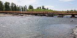 Tamir River near Tsetserleg, Arkhangai | |
| Etymology | Mongolian: tamir = strength, vigor |
| Native name | Тамир гол |
| Location | |
| Country | Mongolia |
| Aimag | Arkhangai |
| Physical characteristics | |
| Source | Northern Tamir |
| • location | Ikh-Tamir sum |
| • coordinates | 47°5′55″N 100°36′20″E |
| 2nd source | Southern Tamir |
| • location | Bulgan sum |
| • coordinates | 46°55′40″N 100°49′35″E |
| Source confluence | |
| • location | Battsengel sum |
| • coordinates | 47°46′10″N 102°1′0″E |
| Mouth | Orkhon River |
• location | Ögii Lake, Ögii Nuur sum |
• coordinates | 47°47′30″N 102°36′40″E |
| Basin features | |
| Progression | Orkhon→ Selenga→ Lake Baikal→ Angara→ Yenisey→ Kara Sea |
For most of its length, the Tamir is divided into two branches, the Northern Tamir (Хойт Тамир гол, Khoit Tamir gol) and the Southern Tamir (Урд Тамир гол, Urd Tamir gol). The Northern Tamir starts between the Shalkhagiin Khoit mountain range and the Togoo Mountain in the Ikh-Tamir sum.[1] The southern Tamir starts about 25 km to the south-west in the Bulgan sum at the end of the Khairkhny mountain range.[2] The two branches run a roughly north-eastern course up to their confluence at the sum center of Battsengel sum.[3]
The Tamir is a main tributary of the Orkhon River, which it meets in Ögii Nuur sum, opposite to the namesake Ögii Lake.[4]
Tamir = strength, vigor
References
- "Russian army map "100k--l47-034"". Maps for the world. Retrieved 2015-01-06.
- "Russian army map "100k--l47-046"". Maps for the world. Retrieved 2015-01-05.
- "Russian army map "100k--l47-012"". Maps for the world. Retrieved 2015-01-05.
- "Russian army map "100k--l48-002"". Maps for the world. Retrieved 2015-01-05.