Tambo River (Peru)
The Tambo River (Spanish: Río Tambo) is a Peruvian river on the eastern slopes of the Andes. The name only refers to a relatively short section; about 159 km (99 mi) long. It starts at the confluence of the Ene and Perené Rivers at the town of Puerto Prado. From here the Tambo River flows 70 km (43 mi) in an easterly direction and then turns north. When merging with the Urubamba River at the town of Atalaya, it becomes the Ucayali River.
| Tambo River | |
|---|---|
.jpg) View of the Tambo River near Puerto Prado | |
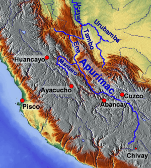 Map of large rivers in south-central Peru | |
| Location | |
| Country | Peru |
| Physical characteristics | |
| Source | Confluence of Ene and Perené Rivers |
| • location | Peru |
| • coordinates | 11°9′56″S 74°14′7″W |
| • elevation | 400 m (1,300 ft) |
| Mouth | Ucayali River |
• location | confluence with Urubamba River, Peru |
• coordinates | 10°41′57″S 73°45′22″W |
• elevation | 287 m (942 ft) |
| Length | 159 km (99 mi) |
The Tambo is part of the headwaters of the Amazon River whose origin is the Mantaro River at Cordilerra Ruminator Cruz .
This article is issued from Wikipedia. The text is licensed under Creative Commons - Attribution - Sharealike. Additional terms may apply for the media files.