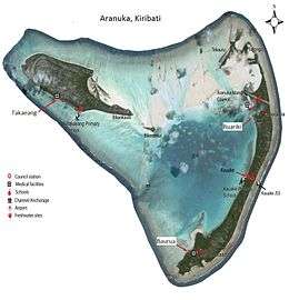
Takaeang
Takaeang is the second largest island in the Aranuka atoll of Kiribati. It helps form the triangular shape of the atoll by forming the top corner of the triangle.[1] It is connected to the larger island, Buariki, by a sandbank.[1]
 Map of Aranuka | |
 | |
| Geography | |
|---|---|
| Location | Pacific Ocean |
| Coordinates | 0°09′N 173°35′E |
| Archipelago | Gilbert Islands |
| Area | 13.228 km2 (5.107 sq mi) |
| Highest elevation | 3 m (10 ft) |
| Administration | |
| Capital | Buariki |
| Demographics | |
| Population | 1,057 (2010 Census) |
| Pop. density | 79.9/km2 (206.9/sq mi) |
| Ethnic groups | I-Kiribati 99.6% |
The village is also called Takaeang.
References
- "10. Aranuka" (PDF). Office of Te Beretitent - Republic of Kiribati Island Report Series. 2012. Retrieved 28 April 2015.
This article is issued from Wikipedia. The text is licensed under Creative Commons - Attribution - Sharealike. Additional terms may apply for the media files.