Taita Hills
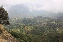
The Taita Hills, sometimes also spelled as Teita Hills, are a precambrian mountain range located in the Taita-Taveta County in south-eastern Kenya. The hills consist of three massifs: Dawida, Sagalla in the southern side of Voi township and Kasigau in the south near the border of Tanzania. The Dawida massif is the largest and tallest of the three, with an altitude of 2,228 metres (7,310 ft) above sea level at its highest peak, Vuria. Dabida has three other main peaks: Iyale, Wesu, and Susu.[1]

Geology
The Taita Hills, with others in the Eastern Arc Mountains, were formed more than one hundred million years ago. About thirty million years ago, the area was covered by extensive rainforest. During a cooler and drier period some ten million years ago, the lowland forests were converted to savanna, leaving the mountain ranges as "islands" where the tropical forests continued to flourish. The isolation of each mountain range has led to a great deal of endemism, and a very diverse flora and fauna. Some of the other mountain ranges are well-forested, but the Taita Hills retain just 6 km2 (2.3 sq mi) of forest.[2] The Taita Hills rise steeply from the Tsavo West National Park.[1]
Ecology
The hills are known for their moist forests with a unique fauna and flora. More than 20 endemic species of African violets (e.g., Saintpaulia teitensiss) occur exclusively in that region. Known endemic bird species are the Taita thrush (Turdus helleri) and the Taita apalis (Apalis fuscigularis). The Taita falcon (Falco fasciinucha) and the Taita fiscal (Lanius dorsalis) were first discovered at the hills but occur elsewhere, too. An amphibian in the genus Boulengerula occurs only in the Taita Hills. The Sagala caecilian (Boulengerula niedeni) is a critically endangered worm-like amphibian that lives in the Taita Hills.[1]
The native Taita people are living at the edge of the forests and farming the soil, which is very productive. 50 % of indigenous forests where replaced by exotic tree plantations between 1955-2004 [3] The region was severely logged in the past and the remaining indigenous forest is now part of a nature reserve, the Taita Hills Wildlife Sanctuary. On the plains and foothills surrounding the hills, the land is predominately used for cropping and grazing. The largest fragments of forest are located in the most inaccessible areas. The land is being degraded by deforestation, the lowering of the water table, and soil erosion. The annual rainfall varies from 500 mm (20 in) in the lowlands to more than three times this amount in the mountain zone. This area experiences two rainy seasons: March to May or June, and October to December, but the precipitation is very variable.[4] Remaining forests are amazingly abundant with all forms of life [5] Taita Hills are home to Small-Eared Greater Galago (Otolemur garnettii) and rare, but locally abundant tree hyrax (Dendrohyrax sp.)
References
- "Taita Hills Forests". Important Bird and Biodiversity Area factsheet. BirdLife International (2016) : Taita Hills Forests. Retrieved 21 October 2016.
- Briggs, Philip (2009). Northern Tanzania: The Bradt Safari Guide with Kilimanjaro and Zanzibar. Bradt Travel Guides. pp. 20–21. ISBN 978-1-84162-292-7.
- Pellikka P. K., Lotjonen M., Siljander M. & Lens L. 2009: Airborne Remote Sensing of Spatiotemporal Change (1955–2004) in Indigenous and Exotic Forest Cover in the Taita Hills, Kenya International Journal of Applied Earth Observation and Geoinformation 11 (2009) 221–232
- Trillo, Richard (2002). Kenya. Rough Guides. p. 381. ISBN 978-1-85828-859-8.
- Wagura 2014, A Guide to Taita Hills.
External links