Tagant Plateau
The Tagant Plateau is located in eastern Mauritania, forming a stony part of the Sahara Desert. The Tagant Region, a national administrative division, is named after the plateau.
Tagant Plateau الهضبة تكانت | |
|---|---|
Natural region | |
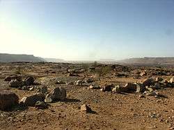 Landscape of the Tagant region in Djouk | |
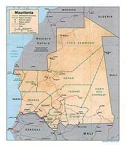 Location of the Tagant plateau in Mauritania | |
| Country | Mauritania |
| Elevation | 400 m (1,300 ft) |
Geography
Some towns are located at the foot of the Tagant Plateau's slopes, which form cliffs in some places. Among these areas are Tichit, Moudjéria and Rachid. Tidjikdja lies on the Tagant itself. The Assaba Massif, where Late Ordovician glacial formations have been identified, is a southward prolongation of the Tagant plateau.[1] The Aoukar, the dry basin of a former lake lies beyond of the southern escarpments of the Tagant Plateau.[2]
History
Beginning in mid-17th century, migrants from the Adrar Plateau region moved in and displaced the native population of the Tagant Plateau.[3]
The Tartega Gueltas oasis is one of the few wetlands in the region where there were still desert crocodiles in 1976,[4] but the population seems to have been last seen in 1996.[5]
See also
References
- M. J. Hambrey, W. B. Harland eds. Earth's Pre-Pleistocene Glacial Record. p. 90
- Tichit - The living ghost of yesterday's glory
- James L. A. Webb, Desert Frontier: Ecological and Economic Change Along the Western Sahel. p.50
- R. H. Hughes, J. S. Hughes, G. M. Bernacsek, A Directory of African Wetlands. p. 57
- de Smet, Klaas (January 1998). "Status of the Nile crocodile in the Sahara desert". Hydrobiologia. SpringerLink. 391 (1–3): 81–86. doi:10.1023/A:1003592123079.
Another relict population [of Nile crocodiles], in the Tagant hills of Mauretania, was found to be probably extinct in 1996.