Tân Thành, Đồng Tháp
Tân Thành (Vietnamese: Xã Tân Thành) is a commune of Lai Vung District, Đồng Tháp Province, in the Mekong Delta region of Vietnam. The commune has an area of 17,9 km², the population of 2009 is 15.748 people, with the density of 884,1 people/km²[1]. In 2013 there are 23.109 people, with a population density of 1.291 people/km²
Tân Thành Xã Tân Thành Cho Lai Vung | |
|---|---|
| Tân Thành | |
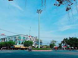 Ngã Năm Tân Thành | |
| Nickname(s): Sla-tamvun | |
| Coordinates: 10°15′42.8″N 105°35′48.3″E | |
| Country | |
| Region | Mekong Delta |
| Province/state | Đồng Tháp Province |
| District/huyện | Lai Vung District |
| Seat | 851 way, Tan Thanh roundabout |
| Area | |
| • Total | 69 sq mi (17,9 km2) |
| Elevation | 20 ft (6 m) |
| Population (2013) | |
| • Total | 23.109 |
| • Density | 3,340/sq mi (1,291/km2) |
| Time zone | UTC+7 (Vietnam) |
| Area code(s) | +84-277 |
| Website | of Tan Thanh Commune |
Geographical location
Tân Thành borders Tân Phước Commune to the north and Long Hậu commune to the east. The Hậu River is to the west, and Vĩnh Thới commune is to the south.
Tân Thành goes to other cities: 17.8 km W of Sa Dec, 22.5 km SE of Long Xuyen, 32.6 km NW of Can Tho, 41.1 km W of Vinh Long
Divisions
Tân Thành commune is divided into 7 Ap; Ap Tân An, Ap Tân Bình, Ap Tân Định, Ap Tân Lợi, Ap Tân Lộc, Ap Tân Khánh and Ap Tân Hưng
Economy
Tân Thành has two large Industrial Zones:
- Sông Hậu Industrial Zone.[2]
- Cái Đôi Industrial Complex 100ha
Education

References
| Wikimedia Commons has media related to Tan Thanh, Lai Vung. |
| Wikivoyage has a travel guide for Tân Thành. |
- "Commune of Vietnam". Statoids. Retrieved April 1, 2009.
| Provincial cities |
|  |
|---|---|---|
| District-level towns |
| |
| Districts | ||