Surveying in North America
Surveying in North America is heavily influenced by the United States Public lands survey system. It inherits the basis of its land tenure from the United Kingdom, as well as the other countries that established colonies, Spain and France.
History
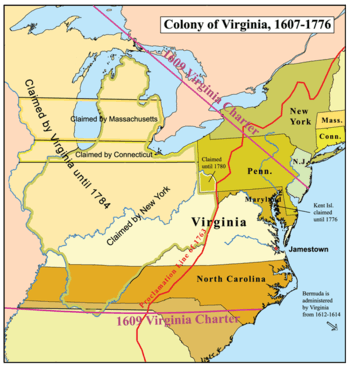
The first European Explorations of North America were quickly followed by territorial claims. The original colonies the made up the United States were granted royal charters that described the limits of the lands where the settlements could be located. Since much of the lands were unknown to Europeans, the grants allocated sweeping areas and were often later amended or superseded. As the population grew and the land was explored, the state borders were defined, like the Mason–Dixon line, finalized in 1767.
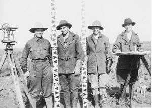
The Lewis and Clark Expedition included a preliminary survey of the features of the western United States, resulting in maps of geographical features.
Organization
The current geodetic model of the earth used in the US is the North American Datum 1983, often called NAD83. The system is used to define horizontal co-ordinates of reference markers all over the US. Although created as a geocentric datum which originates at the center of the earth, more recent models of the earth have shown the origin to be 2.2 m off the centre of the earth. Elevation is recorded against the North American Vertical Datum 1988 (NAVD 88), which uses as its origin point Father Point, in Quebec, Canada. Error in the system is approximately 0.5 mm per mile, resulting in a total error of approximately 1 m from one corner of the continental US to the other.[1]
North American bearings are quadrant bearings.
Licensing
Licensing requirements vary with jurisdiction, and are commonly consistent within national borders.
Canada
In Canada, land surveyors register to work in their respective province. The designation for a land surveyor breaks down by province. It follows the rule whereby the first letter indicates the province, followed by L.S. There is also a designation C.L.S. or Canada lands surveyor. They have the authority to work on Canada lands, which include Indian Reserves, National Parks, the three territories, and offshore lands.
The Canadian version of the PLSS is the Dominion Land Survey.
Mexico
United States
Most of the US recognizes surveying as a distinct profession apart from engineering.
Licensing requirements vary by state,[2] but they have components of education, experience, and examinations. Most states insist upon the basic qualification of a degree in surveying, plus experience and examination requirements. In the past, candidates completed an apprenticeship before taking a series of examinations to gain licensure.
The licensing process follows two phases. Upon graduation, the candidate may take the Fundamentals of Surveying (FS) exam. If they pass and meet the other requirements they become a surveying intern (SI). Upon certification as an SI, the candidate then needs to gain on-the-job experience to become eligible for the second phase. In most states, this is the Principles and Practice of Land Surveying (PS) exam and a state-specific examination. SIs were formerly called surveyors in training (SIT).
Licensed surveyors usually denote themselves with post nominals. The letters PLS (professional land surveyor), PS (professional surveyor), LS (land surveyor), RLS (registered land surveyor), RPLS (Registered Professional Land Surveyor), or PSM (professional surveyor and mapper) follow their names, depending upon their jurisdiction of registration.
References
- "What is the Status of Today's Geodetic Datums?". National Geodetic Survey. US Federal Government. 2 December 2015. Retrieved 30 December 2015.
- "NCEES: Licensure". NCEES. Retrieved 30 December 2015.