Sula, Solund
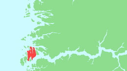
Sula (also called Indre Solundøy) is an island in Solund Municipality in Vestland county, Norway. The 116-square-kilometre (45 sq mi) island is the main island of the municipality. The island is located at the mouth of the Sognefjorden on the north side of the Sognesjøen, about 18 kilometres (11 mi) east of Holmebåen, the westernmost point in Norway. The largest village on the island is Hardbakke. The other main village area is Hersvikbygda on the northern part of the island.[1]
 | |
 Sula Location of the island  Sula Sula (Norway) | |
| Geography | |
|---|---|
| Location | Vestland, Norway |
| Coordinates | 61.1146°N 4.9534°E |
| Archipelago | Solund |
| Area | 116 km2 (45 sq mi) |
| Length | 18 km (11.2 mi) |
| Width | 11 km (6.8 mi) |
| Highest elevation | 569 m (1,867 ft) |
| Highest point | Krakhellenipa |
| Administration | |
Norway | |
| County | Vestland |
| Municipality | Solund Municipality |
| Demographics | |
| Population | 525 (2001) |
| Pop. density | 4.5/km2 (11.7/sq mi)[1] |
The island has a ferry service from the village of Krakhella on the island to the mainland village of Rutledal in Gulen Municipality and also to the village of Losnegard on the neighboring island of Losna, immediately to the east of Sula. Just southwest of Hardbakke, there is a bridge from Sula to the neighboring island of Steinsundøyna to the west. A narrow 65-metre (213 ft) wide channel separates the two islands.[1]
Media gallery
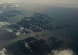 View of Sula island (looking southwest)
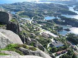 View of Hardbakke, on Sula island