Strumble Head - Llechdafad Cliffs
Strumble Head - Llechdafad Cliffs is a Site of Special Scientific Interest (or SSSI) in Pembrokeshire, South Wales. It has been designated as a Site of Special Scientific Interest since January 1954 in an attempt to protect its fragile biological and geological elements.[1]
| Site of Special Scientific Interest | |
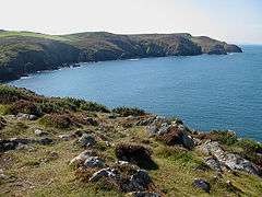 Carreg Onnen Bay from Strumble Head. | |
 Location within Wales | |
| Area of Search | Pembrokeshire |
|---|---|
| Grid reference | SM8927538399 |
| Coordinates | 52.003927°N 5.0714756°W |
| Interest | Biological and Geological |
| Area | 204.63 ha |
| Notification | 1954 |
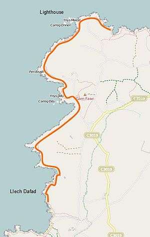
The site, which runs along a coastal strip some 6 miles in length on the western edge of the Strumble Head promontory, broadly covers the area from Strumble Head Lighthouse (on Ynys Meicel) in the north to the cliff named 'Llech Dafad' (sheep slab in Welsh, and spelt as two separate words on the O.S. map) in the south. The SSSI has a total area of 204.63 hectares and is managed by Natural Resources Wales.
The nearest large settlement is the town of Goodwick, some 4 miles away, on the eastern side of the Strumble Head promontory.
Type of site and features
This SSSI has been notified as being of both geological and biological importance. It has 6 special features:
- Maritime cliffs, ledges and crevices
- Coastal grassland
- Coastal heath
- Dry heath
- Rare plants
- Geology: Ordovician igneous and associated rocks
This diversity of habitats supports a wide range of species, including the chough and the small blue butterfly.
References
- Countryside Council for Wales website (Natural Resources Wales since 2013); Archived 2014-01-01 at the Wayback Machine accessdate: 30 December 2013