Stinson Municipal Airport
For the Aberdeen, Mississippi airport see:Stinson Field Municipal Airport
Stinson Municipal Airport Stinson Field | |||||||||||||||||||||||
|---|---|---|---|---|---|---|---|---|---|---|---|---|---|---|---|---|---|---|---|---|---|---|---|
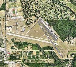 USGS 2006 orthophoto | |||||||||||||||||||||||
| Summary | |||||||||||||||||||||||
| Airport type | Public | ||||||||||||||||||||||
| Owner | City of San Antonio | ||||||||||||||||||||||
| Serves | San Antonio, Texas, USA | ||||||||||||||||||||||
| Elevation AMSL | 577 ft / 176 m | ||||||||||||||||||||||
| Coordinates | 29°20′13″N 098°28′16″W | ||||||||||||||||||||||
| Website | SSF | ||||||||||||||||||||||
| Map | |||||||||||||||||||||||
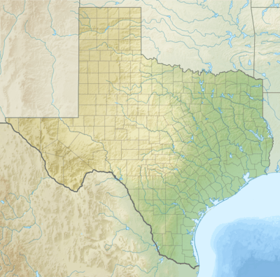 SSF Location of airport in Texas / United States  SSF SSF (the United States) | |||||||||||||||||||||||
| Runways | |||||||||||||||||||||||
| |||||||||||||||||||||||
| Statistics (2011) | |||||||||||||||||||||||
| |||||||||||||||||||||||
Stinson Municipal Airport (IATA: SSF, ICAO: KSSF, FAA LID: SSF) is seven miles south of downtown San Antonio in Bexar County, Texas.[1] The National Plan of Integrated Airport Systems for 2011–2015 categorized it as a reliever airport.[2]
History
Established in 1915 when the Stinson family initially leased the land from the City of San Antonio, Stinson Municipal Airport is the second oldest general aviation airport in continuous operation in the United States [3] (after College Park Airport).
The Works Progress Administration built the terminal building between 1935 and 1936. The building was remodeled and expanded in 2006-2008 but still retains much of its original integrity.
During World War II the airfield was used by the United States Army Air Forces as a training base. At the end of the war the airfield was returned over to the City of San Antonio for civil use.
As the reliever for San Antonio International, the airport has an FBO, three flight schools, police and state aviation units, a part 135 operator, two aerial photography outfits, helicopter tour company and helicopter flight school, and numerous general aviation aircraft. It is also home to the Texas Air Museum. The historic terminal was renovated in 2006-2008 and runway 9-27 re-opened on March 11, 2010 after being re-surfaced and extended to 5002 feet, allowing more private and business jet traffic.[4]
In August 2010 The Texas Wing of the Civil Air Patrol announced it will be moving its statewide headquarters to Stinson Municipal Airport. It was only in Stinson for several years before moving to its current location.
Facilities
The airport covers 360 acres (146 ha) at an elevation of 577 feet (176 m). It has two asphalt runways: 9/27 is 5,000 by 100 feet (1,524 x 30 m) and 14/32 is 4,128 by 100 feet (1,258 x 30 m).[1]
In the year ending March 26, 2011 the airport had 157,044 aircraft operations, average 430 per day: 95% general aviation and 5% military. 42 aircraft were then based at the airport: 76% single-engine, 12% multi-engine, and 12% helicopter.[1]
References
- FAA Airport Master Record for SSF (Form 5010 PDF). Federal Aviation Administration. Effective May 31, 2012.
- "2011–2015 NPIAS Report, Appendix A" (PDF). National Plan of Integrated Airport Systems. Federal Aviation Administration. October 4, 2010. Archived from the original (PDF, 2.03 MB) on September 27, 2012.
- http://www.sanantonio.gov/aviation/stinsonairport.asp Airport website. Accessed September 26, 2007.
- "Stinson airport runway getting redo". My SA News. Retrieved 2010-05-06.
Further reading
- Thole, Lou (1999), Forgotten Fields of America : World War II Bases and Training, Then and Now - Vol. 2. Publisher: Pictorial Histories Pub, ISBN 1-57510-051-7