Sterling Highway
The Sterling Highway is a 138-mile-long (222 km) state highway in the south-central region of the U.S. state of Alaska, leading from the Seward Highway at Tern Lake Junction, 90 miles (140 km) south of Anchorage, to Homer.
| |
|---|---|

Sterling Highway highlighted in red | |
| Route information | |
| Maintained by Alaska DOT&PF | |
| Length | 132 mi[1] (212 km) |
| Existed | 1950–present |
| Major junctions | |
| South end | |
| North end | |
| Highway system | |
| |

Route description
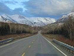
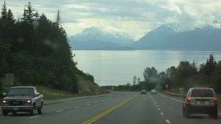
The Sterling Highway is part of Alaska Route 1. It leads mainly west from Tern Lake to Soldotna, paralleling the Kenai River, at which point it turns south to follow the eastern shore of Cook Inlet. It is the only highway in the western and central Kenai Peninsula, and most of the population of the Kenai Peninsula Borough lives near it. The highway also gives access to many extremely popular fishing and recreation areas, including the Chugach National Forest, Kenai National Wildlife Refuge, and the Kenai, Funny, and Russian rivers. The southern end of the highway is at the tip of the Homer Spit, a sandbar extending 4.5 miles (7.2 km) into Kachemak Bay. A ferry terminal here connects the road to the Alaska Marine Highway.[1]
History
Construction of the highway began in 1947 and was completed in 1950.
Major intersections
Mileposts on the Seward Highway begin with Mile 37 (60 km), continuing from the mileposts of the Seward Highway. (The 0 (zero) mile marker for the Seward Highway is in downtown Seward, at the intersection of 3rd and Railway Avenues. Thus, mileposts along the Sterling Highway reflect distance from Seward, which is not actually on the Sterling Highway.
The entire route is in Kenai Peninsula Borough.
| Location | mi[1] | km | Destinations | Notes | |
|---|---|---|---|---|---|
| Homer | 0 | 0.0 | Continues south to Alaska Marine Highway terminal | ||
| Soldotna | 75 | 121 | Kenai Spur Highway north – Kenai | ||
| Chugach National Forest | 132 | 212 | Tern Lake Junction; northern terminus of AK-9 | ||
| 1.000 mi = 1.609 km; 1.000 km = 0.621 mi | |||||
References
- Google (January 11, 2020). "Sterling Highway" (Map). Google Maps. Google. Retrieved January 11, 2020.