Stanley Bay, New Zealand
Stanley Bay on the North Shore, New Zealand is a small suburb near Devonport, Auckland. It is mostly residential. The Devonport Naval Base lies to the east of the bay on the south side of the Stanley Bay peninsula and is connected to storage facilities on the north side at Ngataringa Bay by a tunnel.[1]
Stanley Bay | |
|---|---|
| Country | New Zealand |
| Local authority | Auckland Council |
| Electoral ward | North Shore ward |
| Population (2013) | |
| • Total | 2,187 |
| (Shoal Bay) | (Ngataringa Bay) | (Ngataringa Bay) |
| (Waitemata Harbour) |
|
Devonport |
| (Waitemata Harbour) | (Waitemata Harbour) | (Waitemata Harbour) |
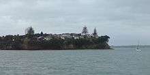
Stanley Point, the westernmost part of Stanley Bay.
The population was 2,187 in the 2013 census, a decrease of 3 from 2006.[2]
Name
The area is named after Owen Stanley, captain of HMS Britomart (1808),[3] who conducted a survey of the Waitemata Harbour in 1841.[4]
Education
Stanley Bay School is a coeducational contributing primary school (years 1–6), with a decile rating of 10 and a roll of 313.[5] The school motto is "Those Who Do Their Best Do Well".[6]
Notes
- Gregory's Auckland & Surrounds Street Directory (3rd ed.). 2008. maps 66–67. ISBN 978-0-7319-2048-8.
- 2013 Census QuickStats about a place : Stanley Bay
- "(1800–1913) Owen Stanley and HMS Britomart". National Museum of the Royal New Zealand Navy. Retrieved 12 April 2019.
- "Stanley Street". Auckland Museum. Retrieved 7 February 2009.
- Education Counts: Stanley Bay School
- "Stanley Bay School". Stanley Bay School. Retrieved 12 April 2019.
External links
- Stanley Bay School
- Chaos In The CBD - 78 To Stanley Bay
- Photographs of Stanley Bay held in Auckland Libraries' heritage collections.
This article is issued from Wikipedia. The text is licensed under Creative Commons - Attribution - Sharealike. Additional terms may apply for the media files.