Spring Creek (Little Kanawha River tributary)
Spring Creek is a tributary of the Little Kanawha River in western West Virginia in the United States. Via the Little Kanawha and Ohio rivers, it is part of the watershed of the Mississippi River, draining an area of 89 square miles (230 km2)[5] in a rural region on the unglaciated portion of the Allegheny Plateau. It is 25.3 miles (40.7 km) long, or 33.3 miles (53.6 km) long including its Left Fork.[6]
| Spring Creek | |
|---|---|
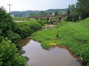 Spring Creek in Spencer in 2006 | |
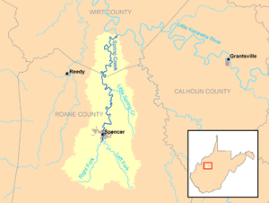 Spring Creek and its watershed | |
| Location | |
| Country | United States |
| State | West Virginia |
| Counties | Roane, Wirt |
| Physical characteristics | |
| Source | Left Fork Spring Creek |
| • location | near Clover, southeast of Spencer, Roane County |
| • coordinates | 38.7156466°N 81.2856741°W[1] |
| • length | 8 mi (13 km) |
| • elevation | 1,033 ft (315 m)[2] |
| 2nd source | Right Fork Spring Creek |
| • location | near Speed, south of Spencer, Roane County |
| • coordinates | 38.728701°N 81.40401°W[3] |
| • length | 7.8 mi (12.6 km) |
| • elevation | 1,041 ft (317 m)[2] |
| Source confluence | |
| • location | south of Spencer, Roane County |
| • coordinates | 38.7892549°N 81.3556755°W[4] |
| • elevation | 724 ft (221 m)[2] |
| Mouth | Little Kanawha River |
• location | Sanoma, Wirt County |
• coordinates | 38.9636934°N 81.3234521°W[4] |
• elevation | 620 ft (190 m)[4] |
| Length | 25.3 mi (40.7 km) |
| Basin size | 89 sq mi (230 km2) |
| Basin features | |
| Tributaries | |
| • right | Little Spring Creek |
Spring Creek is formed just south of the city of Spencer in northern Roane County by the confluence of the Left Fork Spring Creek,[1] 8 miles (13 km) long,[6] which rises near the community of Clover and flows northwestward, paralleled for most of its course by West Virginia Route 36; and the Right Fork Spring Creek,[3] 7.8 miles (12.6 km) long,[6] which rises near the community of Speed and flows northward, paralleled for most of its course by U.S. Route 119. From the confluence of its forks, Spring Creek flows northward through Spencer and northern Roane County into southeastern Wirt County, where it flows into the Little Kanawha River from the south at the community of Sanoma, approximately 8 miles (13 km) southeast of Elizabeth.[7]
Little Spring Creek[8] is a tributary of Spring Creek, 7 miles (11 km) long,[6] in northeastern Roane County.[7]
Charles Mill Lake, approximately 2 miles (3.2 km) southeast of Spencer, is formed by a dam[9] on the Charles Fork,[10] a tributary of the Left Fork Spring Creek.[7] The lake was constructed in 1974 and is owned by the city of Spencer; it is operated as a recreation area for boating, fishing, hiking, biking, and camping.[11]
According to the West Virginia Department of Environmental Protection, approximately 79.5% of the Spring Creek watershed is forested, mostly deciduous. Approximately 18.7% is used for pasture and agriculture.[5]
See also
References
- Geographic Names Information System. "Geographic Names Information System entry for Left Fork Spring Creek (Feature ID #1541725)". Retrieved 2011-10-11.
- Google Earth elevation for GNIS coordinates. Retrieved on 2011-03-11.
- Geographic Names Information System. "Geographic Names Information System entry for Right Fork Spring Creek (Feature ID #1545705)". Retrieved 2011-10-11.
- Geographic Names Information System. "Geographic Names Information System entry for Spring Creek (Feature ID #1547186)". Retrieved 2011-10-11.
- West Virginia Department of Environmental Protection. "Little Kanawha River". Watershed Atlas Project. Archived from the original on 2005-04-04. Retrieved 2011-10-11. External link in
|work=(help) - United States Environmental Protection Agency. "Watershed Assessment, Tracking & Environmental Results: Assessment Summary for Reporting Year 2008, West Virginia, Little Kanawha Watershed". Archived from the original on 2011-10-14. Retrieved 2011-10-13.
- West Virginia Atlas & Gazetteer. Yarmouth, Me.: DeLorme. 1997. pp. 34, 44. ISBN 0-89933-246-3.
- Geographic Names Information System. "Geographic Names Information System entry for Little Spring Creek (Feature ID #1542225)". Retrieved 2011-10-11.
- Geographic Names Information System. "Geographic Names Information System entry for Spring Creek-Charles Fork Number 17 Dam (Feature ID #1559298)". Retrieved 2011-10-11.
- Geographic Names Information System. "Geographic Names Information System entry for Charles Fork (Feature ID #1537212)". Retrieved 2011-10-11.
- "City of Spencer: Charles Fork Lake". Retrieved 2011-10-11.