Southern Moreton Bay Islands (Redland City)
The Southern Moreton Bay Islands, also known as the Bay Islands, the RKLM, and abbreviated as the SMBI, are the four inhabited southern Moreton Bay islands located in South East Queensland, Australia. The group is part of the Redland City with a permanent population of 6,153 as of the 2016 census (was 4,240 as of the 2006 census). However, nearly one-third of all dwellings on the islands were unoccupied, suggesting a high proportion of "second homes" are maintained by people elsewhere on the night of the census.[1]
| Nickname: SMBI, Bay Islands, or RKLM | |
|---|---|
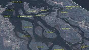 A satellite view from the southwest of south Moreton Bay, Queensland. Labelled are the many islands created from the outflow of the Logan River behind the barrier of North and South Stradbroke Islands. | |
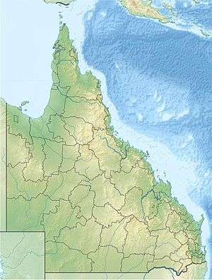 SMBI Location of the Bay Islands in Queensland | |
| Geography | |
| Location | Moreton Bay |
| Coordinates | 27°38′S 153°23′E |
| Major islands | |
| Administration | |
Australia | |
| State | Queensland |
| Region | South East Queensland |
| Local government area | Redland City |
| Demographics | |
| Population | 6,153 (2016 census) |
Demography and development
The four inhabited Bay Islands in 2016 were:
- Karragarra, population 204
- Lamb, population 432
- Russell, population 2836
- Macleay, population 2681
The four inhabited Bay Islands in 2006 were:
- Karragarra, population 125
- Lamb, population 373
- Russell, population 1,776
- Macleay, population 1,957
Tiny Perulpa Island is joined by a causeway to Macleay and is generally regarded as part of Macleay.
In 2007, after a national A Current Affair television news segment, the islands received an enormous amount of interest as having the cheapest land in Australia.
Russell and Macleay have most basic services such as supermarkets, restaurants, primary schools, doctors, police, ambulance, fire brigade, SES, clubs and pubs. Lamb Island has a kiosk with basic supplies and convenience items. Karragarra has no shops at all, which is preferred by the residents.
Originally subdivided in the early 1970s, a bridge was promised by the then government. This never eventuated and residents are now feeling the pressure of transport to the mainland for some shopping trips, as mainland parking has become very scarce.
The Bay Islands enjoy a quiet, relaxed lifestyle with many retirees, pensioners and more recently, an influx of younger families looking for some safety and security, away from the hustle and bustle of the mainland.
The inhabited Southern Moreton Bay Islands are not part of the Southern Moreton Bay Islands National Park, which is also located within Redland City.[2]
Heritage listings
Lamb Island has a number of heritage-listed sites, including:
- Lucas Drive: Lamb Island Pioneer Hall[3]
- Mango Trees on Tina Avenue which were planted over 100 years ago[4]
- Jetty Shed which has been restored by the local island community group and was used for loading local produce onto the merchant boats[4][5]
Macleay Island has a number of heritage-listed sites, including:
- Cliff Terrace: Industrial Ruins, Macleay Island[6]
Transportation
The islands have a frequent scheduled vehicle barge provided by Stradbroke Ferries and fast passenger ferries services provided by Bay Islands Transit, leaving from Redland Bay. Passenger services from Redland Bay to the islands were added to the TransLink network in 2013, allowing passengers to use go cards to ride the ferries.[7] The spectacular Canaipa Passage between North Stradbroke and Russell is a favourite destination for private boats
Telecommunications
The Four Islands are served by two telephone exchanges. Macleay and Lamb Islands are served by the Macleay Island Exchange, while Karragarra and Russell Islands are served by Russell Island Exchange.
The exchanges do not have direct backhaul to the mainland, but are instead connected via Microwave to other larger exchanges. Call Handling is done by the Woolloongabba Exchange.
ADSL Internet has been available to the Islands from 2004/2005 and are capable of ADSL2+ Speeds. Wireless Broadband is available, however several residents report poor reception in some bushy areas. This was combated on Macleay Island by having the Radio Masts raised slightly.
Due to the small-size of the exchange footprint on Russell and Karragarra Islands, some residents are not able to receive ADSL, this is due to the copper line's length being beyond maximum standards (5 km). Mainly people living off Centre Road and Canaipa Road. Residents have lobbied Telstra to install Roadside Cabinets at some of the worst affected areas, so that they can receive Internet services, but have been repeatedly ignored. Most residents outside the Exchange Footprint for ADSL have to resort to Wireless Broadband, and in many cases Satellite Internet. This also applies to Macleay and Lamb Islands as well.
Foxtel Digital PayTV is available via satellite.
References
- "Russell, Karragarra, Lamb and Macleay". Australian Bureau of Census. 2006.
- "Redland (C)" (PDF). Queensland Local Government Areas (LGA), 2011. Queensland Government. Archived from the original (PDF) on 29 October 2013. Retrieved 28 October 2013.
- "Lamb Island Pioneer Hall (entry 601493)". Queensland Heritage Register. Queensland Heritage Council. Retrieved 12 July 2013.
- "Schedule 4 - Heritage Places Register". Redland City Council. Archived from the original on 4 February 2015. Retrieved 3 February 2015.
- "Lamb Island". Archived from the original on 4 February 2015. Retrieved 3 February 2015.
- "Industrial Ruins, south end of Macleay Island (entry 601062)". Queensland Heritage Register. Queensland Heritage Council. Retrieved 12 July 2013.
- Kerr, Judith (17 December 2012). "Bay islands added to Translink network". Brisbane Times. Retrieved 10 March 2020.