South Swedish highlands
The South Swedish highlands or South Swedish Uplands[1] (Swedish: Sydsvenska höglandet) is a hilly area covering large parts of Götaland in southern Sweden. Except for a lack of deep valleys, the landscape is similar to the Norrland terrain found further north in Sweden.[2] The central-eastern parts of the highlands contain about thirty narrow canyons locally known as skurus.[3]
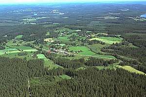
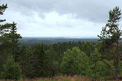
Much of the highlands lies above 200 m.a.s.l. and there are large areas around the highlands that exceed 100 m.a.s.l. The highlands are centered on Småland but cover also large swathes of Scania, Halland, Västergötland, Östergötland and Blekinge.[4] The highest point lies 377 m.a.s.l.[5]
History
The South Swedish highlands have been populated since the Nordic Stone Age as evidenced by cist findings.[6] During the Nordic Bronze Age (c. 1700–500 BC) there was a significant agricultural expansion across the highlands. Soils developed on glacial till were cleared with stones being pile-up in cairns.[6][7] Other periods of agricultural expansion are the Roman Iron Age and the High Middle Ages (c. 13th century).[7]
Poor soil conditions have posed significant difficulties for agriculture in the highlands, meaning that over time small industries became relatively important in local economies.[6] Many abandoned fields are now covered with forest. Vestiges of abandoned fields can be recognised through the highlands by characteristic heaps of stones made when soils where cleared for cultivation.[6]
Climate and weather events
The climate of the western parts of the highlands is more humid than on the east. This is due to orographic precipitation caused by southwestern wind forcing moist air over the highlands.[8] Lake Sommen in the northeastern part of the highlands har relatively low humidity and low precipitations.[9] Ljungby in the southwestern parts of the highlands hold the monthly precipitation record for Småland with 347 mm in August 1945.[8] The South Swedish highlands host the record locations for coldest and hottest temperatures in Southern Sweden.[8] The cold record is -38.5 °C on January 16 1918 in Lommaryd.[8] While the hot record is 38 °C on June 29, 1947 in Målilla.[8]
The South Swedish highlands are less exposed to storms than the southern and western coasts of Sweden, yet storms can still be very destructive.[8] The 2005 storm Gudrun was particularly strong causing much damage to forests in the southwestern part of the highlands.[8][10] Spruces were particularly hit by Gudrun, while other trees with a more steady root system fared better.[10] Damage was exacerbated by the intential planting of spruces and practice of clearcutting which left many trees exposed to the wind.[10] Gudrun also caused blackouts and disabled telecommunications infrastructure through the highlands.[8][10]
Geology

Within a geological context the highlands are the expression of the South Swedish Dome.[5] The South Swedish Dome has been subsided and been uplifted multiple times by epeirogenic movements during the Phanerozoic. The dome has had periods of subsidence and burial in sediments have alternated with periods of exhumation and the formation of peneplains and hilly relief. The Sub-Cambrian peneplain of Late Neoproterozoic age is the oldest of the surfaces. It covers the eastern and northern flanks of the dome and its crest region where it is up-broken.[11][12] The mesozoic-aged Sub-Mesozoic hilly relief covers the southern and western fringes of the dome, corresponding roughly with the counties of Halland, Blekinge and northeastern Scania. The youngest well-defined surface is the South Småland peneplain that formed in the Neogene.[11] In detail the South Swedish Dome has the form of a piedmonttreppen or staircase of erosion surfaces. From top to bottom the levels are:[1]
- the crestal and upbroken portions of the Sub-Cambrian peneplain
- the 300 m a.s.l. peneplain[upper-alpha 1]
- the 200 m a.s.l. peneplain, containing various inselbergs.[12][upper-alpha 2]
- the South Småland peneplain (175–125 m a.s.l.)[upper-alpha 3]
- the 100 m a.s.l. surface which is part of the South Småland peneplain
The Late Cenozoic uplift of the dome is tentatively related to far-field compressional stresses that has uplifted the region as a giant anticline-like lithosphere fold. As such it is similar to uplifted passive margins like the Scandinavian Mountains or the mountains of Western and Eastern Greenland.[14]
Last ice age and deglaciation
During the last deglaciation of the Weichselian Ice Sheet the South Swedish highlands was a place of ice flow divergence.[15] Deglaciation of southern Sweden was relatively slow with ice margin retreat rates of less than 150 m/yr. The retreat was interrupted multiple times by small glacier advances. These advances led to the formation of a series of end moraine systems. During deglaciation in southern Sweden glacier ice was mostly warm-based with some lesser parts being cold-based.[16]
At present various lakes in the South Swedish highlands contain planktonic crustacean species that are relics from the time the Weichselian Ice Sheet left the area about 12,000 years ago.[17][16] Lake Sommen stands out for having as much as three glacial relict crustcean species. These species are Pallasea quadrispinosa, Mysis affinis and Limnocalanus macrurus. Yet the lake lacks the most common relict crustacean found in the lakes of southern Sweden, the Mysis relicta.[17]
Notes
- This level was considered as part of a post-Silurian peneplain by Sten Rudberg as it could be matched to hills in Västergötland (Kinnekulle, Halleberg, Hunneberg and Billingen).[1][13] Karna Lidmar-Bergström consider this correlation plausible but the evidence tenuous.[13]
- The existence of this surface was first noted by S. Nordlindh in 1924 in a monograph about hydropower and topography.[13]
- The South Småland peneplain was first noted by Sten De Geer in 1913.[13]
References
- Lidmar-Bergström, Karna; Olvmo, Mats; Bonow, Johan M. (2017). "The South Swedish Dome: a key structure for identification of peneplains and conclusions on Phanerozoic tectonics of an ancient shield". GFF.
- Lundqvist, Jan (1969). "Landskapet". In Lundqvist, Magnus (ed.). Det Moderna Sverige (in Swedish). Bonniers. pp. 64–67.
- Olvmo, Mats (2006). "Skuruna i Småland". Geologiskt Forum (in Swedish). 50: 8–11. Retrieved April 22, 2019.
- Åkerhielm, Erik (1912). "Sydsvenska höglandet". Geografien i skildingar och bilder (in Swedish). Lund. pp. 49–90. Retrieved June 7, 2015.
- Lidmar-Bergström, Karna; Bonow, Johan M.; Japsen, Peter (2013). "Stratigraphic Landscape Analysis and geomorphological paradigms: Scandinavia as an example of Phanerozoic uplift and subsidence". Global and Planetary Change. 100: 153–171. Bibcode:2013GPC...100..153L. doi:10.1016/j.gloplacha.2012.10.015.
- "Kulturspår på sydsvenska höglandet". Skogskunskap (in Swedish). November 6, 2016. Retrieved May 10, 2019.
- Lagerås, Per (2013). "Agrara fluktuationer och befolknings-utveckling på sydsvenska höglandet tolkade utifrån röjningsrösen". Fornvännen (in Swedish). 108 (4): 263–277.
- "Smålands klimat". SMHI (in Swedish). January 16, 2018. Retrieved May 10, 2019.
- "4. östra Götalands sprickdals- och eklandskap". Skogliga naturvärdesregioner för södra Sverige [Forest biodiversity regions in southern Sweden] (PDF) (Report) (in Swedish). Södra. 2015. p. 66.
- "Skogsskador efter Gudrun". SMHI (in Swedish). July 8, 2015. Retrieved May 10, 2019.
- Japsen, Peter; Green, Paul F.; Bonow, Johan M.; Erlström, Mikael (2016). "Episodic burial and exhumation of the southern Baltic Shield: Epeirogenic uplifts during and after break-up of Pangaea". Gondwana Research. 35: 357–377. Bibcode:2016GondR..35..357J. doi:10.1016/j.gr.2015.06.005.
- Lidmar-Bergström, Karna. "Sydsvenska höglandet". Nationalencyklopedin (in Swedish). Cydonia Development. Retrieved November 30, 2017.
- Lidmar-Bergström (1988). "Denudation surfaces of a shield area in southern Sweden". Geografiska Annaler. 70 A (4): 337–350.
- Japsen, Peter; Chalmers, James A.; Green, Paul F.; Bonow, Johan M. (2012). "Elevated, passive continental margins: Not rift shoulders, but expressions of episodic, post-rift burial and exhumation". Global and Planetary Change. 90–91: 73–86. Bibcode:2012GPC....90...73J. doi:10.1016/j.gloplacha.2011.05.004.
- Lundqvist, Jan; Lundqvist, Thomas; Lindström, Maurits; Calner, Mikael; Sivhed, Ulf (2011). "Svekokarelska Provinsen". Sveriges Geologi: Från urtid till nutid (in Swedish) (3rd ed.). Spain: Studentlitteratur. p. 515. ISBN 978-91-44-05847-4.
- Stroeven, Arjen P; Hättestrand, Clas; Kleman, Johan; Heyman, Jakob; Fabel, Derek; Fredin, Ola; Goodfellow, Bradley W; Harbor, Jonathan M; Jansen, John D; Olsen, Lars; Caffee, Marc W; Fink, David; Lundqvist, Jan; Rosqvist, Gunhild C; Strömberg, Bo; Jansson, Krister N (2016). "Deglaciation of Fennoscandia". Quaternary Science Reviews. 147: 91–121. Bibcode:2016QSRv..147...91S. doi:10.1016/j.quascirev.2015.09.016.
- Kinsten, Björn (2010). De glacialrelikta kräftdjurens utbredning i södra Sverige (Götaland och Svealand) (PDF) (Report) (in Swedish). Länsstyrelsen Blekinge län. pp. 1–19. Retrieved April 19, 2019.