South Otterington
South Otterington is a village and civil parish in the Hambleton district of North Yorkshire, England. It is located on the A167 road 5 miles (8 km) south of Northallerton and on the east bank of the River Wiske.
| South Otterington | |
|---|---|
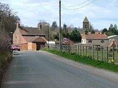 Approaching South Otterington from the east | |
 South Otterington Location within North Yorkshire | |
| Population | 347 (2011 census)[1] |
| OS grid reference | SE374875 |
| Civil parish |
|
| District | |
| Shire county | |
| Region | |
| Country | England |
| Sovereign state | United Kingdom |
| Post town | NORTHALLERTON |
| Postcode district | DL7 |
| Police | North Yorkshire |
| Fire | North Yorkshire |
| Ambulance | Yorkshire |
| UK Parliament | |
History
The village is mentioned in the Domesday Book as Otterinctune in the Allerton hundred. The manor was split between Egelfride and Haldor at the time of the Norman invasion and subsequently passed to the Crown.[2]
Part of the manor was granted to Robert Brus, whose family held it until 1242 when it was granted to Byland Abbey who held it until the dissolution. Another part of the manor was granted to the Fossard family who held it until 1279 when it was passed to Richard Malbiche. At some point in the early 17th century, most of the lands of the manor had found their way into the possession of the Talbot family in nearby Thornton-le-Moor. The name is probably from Old English relating to a person named Otter and the suffix -tun meaning settlement.[3][4]
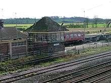
The village was served by a station on the North Eastern Railway. The station, called Otterington, was opened on 31 March 1841 and closed to passengers 15 September 1958 before final closure on 10 August 1964. The station was located next to the road bridge over the lines.[5][6]
Governance
The village is within the Thirsk and Malton UK Parliament constituency. It lies within the Thorntons ward of Hambleton District Council and Sowerby electoral division of North Yorkshire County Council.[7]
Geography
The nearest settlements are Newby Wiske 0.5 miles (0.80 km) to the west and Thornton-le-Moor 1.1 miles (1.8 km) to the east. The village is located on the east bank of the River Wiske and directly on the A167 road. Howe Beck flows through the north end of the village to join the River Wiske. The East Coast Main Line passes to the east of the village.[7]
The 1881 UK Census recorded the population as 349.[4] The 2001 UK Census recorded the population as 344, of which 269 were over the age of sixteen years and of those, 181 were in employment. There were 141 dwellings of which 85 were detached. The split of male to females was 47.4% and 52.6% respectively. The mean age of the population was 37.98 years old.[8]
Education
There was a school built in the village in 1856.[4] A new building, South Otterington CE Primary School, was built in 1993 to accommodate an expansion in pupil numbers following the closure of the schools in nearby Newby Wiske and Thornton-le-Moor. It incorporates pre-school facilities.[9]
Religion
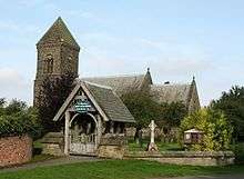
There is a church in the village dedicated to St Andrew. It is a Grade II Listed building[10] that was rebuilt in 1846 on the site of the previous Norman building.[4]
Notable inhabitants
- Andy Preston, the Mayor of Middlesbrough and a former hedge fund manager, has lived at Otterington Hall since at least 2007.[11]
References
- UK Census (2011). "Local Area Report – South Otterington Parish (1170216926)". Nomis. Office for National Statistics. Retrieved 11 June 2018.
- South-Otterington in the Domesday Book. Retrieved 6 January 2013.
- "Local History". Retrieved 6 January 2012.
- Bulmer's Topography, History and Directory (Private and Commercial) of North Yorkshire 1890. S&N Publishing. 1890. pp. 772, 773. ISBN 1-86150-299-0.
- "Disused Station". Retrieved 6 January 2012.
- Butt, R. V. J. (1995). The Directory of Railway Stations: details every public and private passenger station, halt, platform and stopping place, past and present (1st ed.). Sparkford: Patrick Stephens Ltd. ISBN 978-1-85260-508-7. OCLC 60251199.CS1 maint: ref=harv (link)
- Ordnance Survey Open Viewer
- "2001 UK Census". Neighbourhood Statistics. Office for National Statistics. Retrieved 17 December 2012.
- "School". Retrieved 6 January 2013.
- "Church Listing". Retrieved 6 January 2013.
- "Top topiary is ready after a precision clip". Darlington and Stockton Times. 7 September 2007. Retrieved 6 May 2020.
External links
![]()