South Carolina Highway 557
South Carolina Highway 557 (SC 557) is a primary state highway in the U.S. state of South Carolina. It serves as a connector route between Clover and Lake Wylie.
| ||||
|---|---|---|---|---|
 | ||||
| Route information | ||||
| Maintained by SCDOT | ||||
| Length | 6.71 mi[1] (10.80 km) | |||
| Existed | 1942–present | |||
| Major junctions | ||||
| South end | ||||
| North end | ||||
| Location | ||||
| Counties | York | |||
| Highway system | ||||
| ||||

Route description
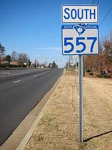
First sign for SC 557 south in Lake Wylie
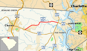
SC 557 is a two-lane rural highway that traverses 6.7 miles (10.8 km) from SC 55 near Clover to SC 49/SC 274 in Lake Wylie. The highway provides travelers a more direct route to and from Charlotte. Though it runs physically west-to-east, it is signed as a north-south highway with its western end as its southern terminus and vice versa.[2]
History
The highway was established in 1942 as a renumbering of SC 59. The route has changed little since.[3]
Junction list
The entire route is in York County.
| Location | mi[1] | km | Destinations | Notes | |
|---|---|---|---|---|---|
| Clover | 0.00 | 0.00 | |||
| Lake Wylie | 6.71 | 10.80 | |||
| 1.000 mi = 1.609 km; 1.000 km = 0.621 mi | |||||
References
- "Statewide Highways (shapefile)" (zip). South Carolina Department of Transportation. September 29, 2017. Retrieved December 8, 2017.
- Google (January 8, 2012). "South Carolina Highway 557" (Map). Google Maps. Google. Retrieved January 8, 2012.
- "Mapmikey's South Carolina Highways Page: SC 557". Retrieved January 8, 2012.
External links
| Wikimedia Commons has media related to South Carolina Highway 557. |
This article is issued from Wikipedia. The text is licensed under Creative Commons - Attribution - Sharealike. Additional terms may apply for the media files.