South Carolina Highway 421
South Carolina Highway 421 (SC 421) is a primary state highway in the U.S. state of South Carolina. It is an alternate route to U.S. Route 1 (US 1) and US 78 between North Augusta and Aiken.
| ||||
|---|---|---|---|---|
| Augusta Road | ||||
 | ||||
| Route information | ||||
| Maintained by SCDOT | ||||
| Length | 10.36 mi[1] (16.67 km) | |||
| Existed | 1952–present | |||
| Major junctions | ||||
| South end | ||||
| North end | ||||
| Location | ||||
| Counties | Aiken | |||
| Highway system | ||||
| ||||

Route description
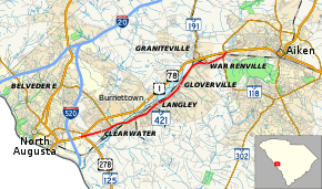
SC 421 begins where it splits off from US 1/US 78 (Jefferson Davis Highway) west of North Augusta; it immediately connects with US 278/SC 125 (Atomic Road). Heading northeast, it parallels US 1/US 78 to its south, going through the towns of Clearwater, Burnettown, Langley, Gloverville and Warrenville. Upon entering Aiken, it reconnects with US 1/US 78. A majority of the highway is four-lanes that travels a total of 10.4 miles (16.7 km).[2]
History
SC 421 was established by 1952 as a renumbering of US 1/US 78, which was realigned onto new four-lane routing just north of it. The route has remained unchanged since inception.[3][4]
Major intersections
The entire route is in Aiken County.
| Location | mi[1] | km | Destinations | Notes | |
|---|---|---|---|---|---|
| Clearwater | 0.00 | 0.00 | Northbound lane only | ||
| 0.44 | 0.71 | Southbound lane exit onto interchange | |||
| 1.91 | 3.07 | ||||
| Warrenville | 8.15 | 13.12 | |||
| Aiken | 10.03 | 16.14 | |||
| 10.36 | 16.67 | ||||
| 1.000 mi = 1.609 km; 1.000 km = 0.621 mi | |||||
See also


References
- South Carolina Department of Transportation: Statewide Highways 2012. Specifics: . Files: .
- South Carolina Highway 421 (Map). Cartography by Google. Google Maps. 2010.
- General Highway Map, Aiken County, South Carolina (PDF) (Map). Cartography by SCDOT. South Carolina Department of Transportation. 1940. Retrieved September 8, 2013.
- General Highway Map, Aiken County, South Carolina (PDF) (Map). Cartography by SCDOT. South Carolina Department of Transportation. 1956. Retrieved September 8, 2013.
External links

- Mapmikey's South Carolina Highways Page: SC 410-429