South Carolina Highway 412
South Carolina Highway 412 (SC 412) is a seven-mile-long (11 km) state highway in the U.S. state of South Carolina. The highway connects rural areas of Anderson County with Starr.
| ||||
|---|---|---|---|---|
 | ||||
| Route information | ||||
| Maintained by SCDOT | ||||
| Length | 7.03 mi[1] (11.31 km) | |||
| Tourist routes | ||||
| Major junctions | ||||
| West end | ||||
| East end | ||||
| Location | ||||
| Counties | Anderson | |||
| Highway system | ||||
| ||||

Route description
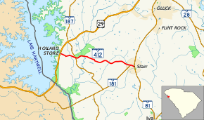
SC 412 begins at an intersection with U.S. Route 29 (US 29) west-northwest of Starr, within unincorporated Anderson County community of Holland Store. It travels in a fairly east-southeasterly direction. It crosses over Lucas Creek before it intersects SC 187. The highway crosses over Big Generostee and Generostee creeks. A short distance after crossing Weems Creek, it passes Starr–Iva Middle School. In Starr, it intersects the northern terminus of SC 181 (Smith–McGee Road) just before it meets its eastern terminus, an intersection with SC 81. Here, the roadway continues as First Avenue.[2]
Major intersections
The entire route is in Anderson County.
| Location | mi[2] | km | Destinations | Notes | |
|---|---|---|---|---|---|
| Holland Store | 0.00 | 0.00 | |||
| | 1.50 | 2.41 | |||
| Starr | 6.64 | 10.69 | Northern terminus of SC 181 | ||
| 7.03 | 11.31 | ||||
| 1.000 mi = 1.609 km; 1.000 km = 0.621 mi | |||||
See also


References
- "Statewide Highways (shapefile)" (zip). South Carolina Department of Transportation. September 29, 2017. Retrieved December 8, 2017.
- Google (May 15, 2016). "South Carolina Highway 412" (Map). Google Maps. Google. Retrieved May 15, 2016.
External links

- SC 413 - South Carolina Hwy Index Home