South Carolina Highway 265
South Carolina Highway 265 (SC 265) is a primary state highway in the U.S. state of South Carolina. It serves to connect Jefferson with the cities of Kershaw and Chesterfield.
| ||||
|---|---|---|---|---|
| ||||
| Route information | ||||
| Maintained by SCDOT | ||||
| Length | 24.5 mi[1] (39.4 km) | |||
| Existed | 1928–present | |||
| Major junctions | ||||
| West end | ||||
| East end | ||||
| Location | ||||
| Counties | Lancaster, Chesterfield | |||
| Highway system | ||||
| ||||

Route description
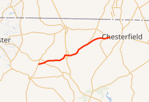
SC 265 is a two-lane rural highway that traverses 24.5 miles (39.4 km) from U.S. Route 601 (US 601) north of Kershaw to SC 9 near Ruby.
History
The highway was established in 1928 as a new primary routing from SC 26 in Kershaw to SC 9 near Ruby. In 1940, it was extended southwest to SC 97 in Liberty Hill. In 1948, it was reduced back to its original route from 1928-1940. In 1951 or 1952, SC 265 was shortened to its current eastern terminus with US 601.[2]
Junction list
| County | Location | mi[1] | km | Destinations | Notes |
|---|---|---|---|---|---|
| Lancaster | | 0.0 | 0.0 | ||
| | 2.0 | 3.2 | |||
| Chesterfield | Jefferson | 9.4 | 15.1 | ||
| 10.0 | 16.1 | ||||
| | 17.1 | 27.5 | |||
| Ruby | 22.5 | 36.2 | |||
| 24.5 | 39.4 | ||||
| 1.000 mi = 1.609 km; 1.000 km = 0.621 mi | |||||
References
- Google (September 6, 2012). "South Carolina Highway 265" (Map). Google Maps. Google. Retrieved September 6, 2012.
- "Mapmikey's South Carolina Highways Page". Retrieved September 6, 2012.
External links

This article is issued from Wikipedia. The text is licensed under Creative Commons - Attribution - Sharealike. Additional terms may apply for the media files.