South Carolina Highway 260
South Carolina Highway 260 (SC 260) is a 12.5-mile-long (20.1 km) state highway in the U.S. state of South Carolina. The highway connects the Santee Dam and Manning.
| ||||
|---|---|---|---|---|
 | ||||
| Route information | ||||
| Maintained by SCDOT | ||||
| Length | 12.52 mi[1] (20.15 km) | |||
| Major junctions | ||||
| South end | Santee Dam/Lake Marion in Eagle Point | |||
| North end | ||||
| Location | ||||
| Counties | Clarendon | |||
| Highway system | ||||
| ||||

Route description
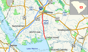
SC 260 begins just north of the Santee Dam (which lies at the eastern end of Lake Marion) at a locale known as Eagle Point, within Clarendon County. It crosses over a part of the northeastern part of the lake. After it started curving to the north, it crosses over Birch Branch and part of White Oak Branch. It then passes the Clarendon County Airport – Sprott Field, which is just east of the Wyboo Golf Club. The highway crosses over Ox Swamp and Hog Branch just before entering Manning. In the city, it passes Clarendon Memorial Hospital, then has an intersection with U.S. Route 301 (US 301; Sunset Drive). About three blocks later, it meets its northern terminus, an intersection with SC 261 (West Boyce Street). Here, the roadway continues as North Mill Street.[2]
Major intersections
The entire route is in Clarendon County.
| Location | mi[1] | km | Destinations | Notes | |
|---|---|---|---|---|---|
| Santee Dam | 0.0 | 0.0 | Emma Lane | ||
| Manning | 12.26 | 19.73 | |||
| 12.52 | 20.15 | ||||
1.000 mi = 1.609 km; 1.000 km = 0.621 mi
| |||||
See also


References
- "Statewide Highways (shapefile)" (zip). South Carolina Department of Transportation. September 29, 2017. Retrieved December 8, 2017.
- Google (May 12, 2016). "South Carolina Highway 260" (Map). Google Maps. Google. Retrieved May 12, 2016.
External links

- SC 260 South Carolina Hwy Index