South Carolina Highway 193
South Carolina Highway 193 (SC 193) is a 6.9-mile-long (11.1 km) state highway in the U.S. state of South Carolina. The highway connects Ward and rural areas of Saluda County.
| ||||
|---|---|---|---|---|
 | ||||
| Route information | ||||
| Maintained by SCDOT | ||||
| Length | 6.93 mi[1] (11.15 km) | |||
| Major junctions | ||||
| South end | ||||
| North end | ||||
| Location | ||||
| Counties | Saluda | |||
| Highway system | ||||
| ||||

Route description
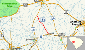
SC 193 begins at an intersection with SC 23 (Front Street) in Ward, within Saluda County, where the roadway continues as Mt. Alpha Road. It travels to the north-northwest and leaves town. It crosses over Dry Creek. After it curves to the northwest, it crosses over Mine Creek and Little Mine Creek in quick succession. The highway passes Saluda County Airport just before meeting its northern terminus, an intersection with SC 121, south-southwest of Saluda, where the roadway continues as Gabe Road.[2]
Major intersections
The entire route is in Saluda County.
| Location | mi[1] | km | Destinations | Notes | |
|---|---|---|---|---|---|
| Ward | 0.00 | 0.00 | |||
| | 6.93 | 11.15 | |||
| 1.000 mi = 1.609 km; 1.000 km = 0.621 mi | |||||
See also


References
- "Statewide Highways (shapefile)" (zip). South Carolina Department of Transportation. September 29, 2017. Retrieved December 8, 2017.
- Google (May 10, 2016). "South Carolina Highway 193" (Map). Google Maps. Google. Retrieved May 10, 2016.
External links

- SC 193 South Carolina Hwy Index
This article is issued from Wikipedia. The text is licensed under Creative Commons - Attribution - Sharealike. Additional terms may apply for the media files.