South Carolina Highway 128
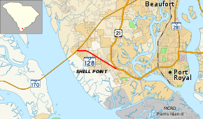
South Carolina Highway 128 (SC 128), is a two-mile-long (3.2 km) state highway located entirely within Beaufort County, South Carolina. Also known locally as Savannah Highway, SC 128 serves as a principal arterial for the unincorporated Shell Point as well as providing a southern route serving Port Royal, Parris Island and the Sea Islands east of Beaufort.
| ||||
|---|---|---|---|---|
| Savannah Highway | ||||
 | ||||
| Route information | ||||
| Maintained by SCDOT | ||||
| Length | 1.97 mi[1] (3.17 km) | |||
| Existed | 2012–present | |||
| Major junctions | ||||
| West end | ||||
| East end | ||||
| Location | ||||
| Counties | Beaufort | |||
| Highway system | ||||
| ||||

Route description
SC 128 runs in a west-to-east direction and is a four-lane road for the entirety of the route. It alternates between traveling through the census-designated place of Shell Point and the town of Port Royal. SC 128 travels along the entirety of Savannah Highway. Beginning at an intersection with SC 170 just before the Broad River Bridge, SC 128 travels east towards its eastern terminus at U.S. Highway 21 (US 21).[2]
History
Until 2012, SC 128 was signed as SC 802. With the re-routing of US 21 around Beaufort, the route for SC 802 was truncated to its current location on Lady's Island, thus resulting in the designation of SC 128 for the remaining portion of the old SC 802 route.
Major Intersections
The entire route is in Beaufort County.
| Location | mi[1] | km | Destinations | Notes | |
|---|---|---|---|---|---|
| Port Royal | 0.00 | 0.00 | |||
| 1.97 | 3.17 | ||||
| 1.000 mi = 1.609 km; 1.000 km = 0.621 mi | |||||
References
- South Carolina Department of Transportation: Statewide Highways 2012. Specifics: . Files: .
- Google (February 16, 2018). "South Carolina Highway 128" (Map). Google Maps. Google. Retrieved February 16, 2018.
External links
| Wikimedia Commons has media related to South Carolina Highway 128. |