Source of the Amazon River
The Source of the Amazon River has been a subject of speculation and exploration for centuries. Three definitions can apply to determining the source of a river. The source can be defined as the most distant upstream point in the drainage basin, or the most distant upstream point of the largest stream (the main stem) of the river, or the most distant source of an uninterrupted flow of water.[1] The source of the Amazon River has been attributed to the headwaters of three different Peruvian rivers in the high Andes: the Marañón, the Apurímac, and the Mantaro.
Explorers and scholars have identified each of the three rivers as being the source of the Amazon under one of the three definitions. The Mantaro is the most distant upstream point; the Marañón is the main stem of the Amazon; and the Apurímac is the most distant source with an uninterrupted flow of water.
Background
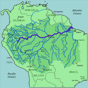
The Amazon River is the largest river in the world in terms of its discharge into the Atlantic Ocean and either the longest or second longest river in the world, contending with the Nile River for that honor. More than 3,700 kilometres (2,300 mi) from its mouth, upstream from the city of Iquitos, Peru, the Amazon divides into the Marañón and the Ucayali Rivers. The Marañón is the shorter of the two rivers but has the largest flow. The two most distant tributaries from the mouth of the Amazon are the Ucayali tributaries, the Apurimac and Mantaro Rivers.[2]
The Marañón, Apurimac, and Mantaro rivers originate in the high Andes of Peru at elevations of more than 5,000 metres (16,000 ft) above sea level. All three have been claimed as the source of the Amazon. The Marañón can claim to be the mainstream source of the Amazon, but the Ucayali and its tributaries are longer, 2,738 kilometres (1,701 mi) compared to 1,415 kilometres (879 mi) for the Maraňon.[3][4]
The Marañón source
A Jesuit priest named Samuel Fritz published accounts of his life among the Indigenous people living along the Amazon and Marañón Rivers. The map he drew in 1707 showed the Marañón as larger than the Ucayali, and thus the main stream of the Amazon. He identified the source of the Marañón as Lake Lauricocha in the Andes. [5][6] Lake Lauricocha is located at -10.313 Latitude, and -76.696 Longitude and has a surface elevation of 3,856 metres (12,651 ft).[7] The stream issuing from Lake Lauricocha is called the Lauricocha River. A few miles down its course it joins the Nupe River and is afterwards known as the Marañón.
Fritz's opinion about the source of the Amazon went unchallenged for nearly 200 years. However, in the late 19th century, the Italian-born geographer Antonio Raimondi said that Lake Lauricocha was not the real source of the Amazon, but rather the Nupe River which he said was larger and longer than the Lauricocha River.[8] The Nupe rises from a chain of small lakes below Siula Grande, one of the highest peaks of the Huayhuash Range. The coordinates of Quesillococha, the uppermost lake, are -10.282 Latitude and -76.869 Longitude. Its elevation is 4,351 metres (14,275 ft).[9]
In 1951 and 1952, two Englishmen, Sebastian Snow and John Brown, joined an expedition to confirm the source of the Amazon. Finding their way to Lake Lauricocha, they found a stream flowing into the lake which they followed through the Raura silver mine to a small glacier-fed lake, called Niñococha, in the Raura mountain range. They declared Niňococha the source of the Amazon. Starting at the lake, Snow descended the Amazon River all the way to its mouth in the Atlantic Ocean.[10] Lake Niñococha is located at -10.458 Latitude and -76.764 Longitude at an elevation of 4,964 metres (16,286 ft).[11]
The Apurímac source
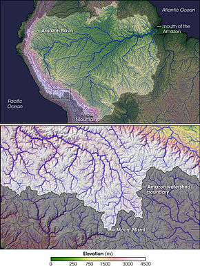
Attention turned to the headwaters of the Apurímac River as early as 1935 when Lake Vilafro (-15.203, -71.880, 4,674 metres (15,335 ft) in elevation[12]) was identified as the source of the Amazon. Several other places in that vicinity were named in the decades that followed with the Carhuasanta River, flowing down from Mismi mountain, first identified as a possible ultimate source in 1969 by Carlos Peñaherrera del Aguila.[13] In 1971, Loren McIntyre led a National Geographic Society expedition to this remote area, frequented only by llama and alpaca herders. On the northern slopes of Mismi, at the headwaters of the Carhuasanta, McIntyre identified a small pond as the source of the Amazon.[14] He named the pond Lake McIntyre and later it appeared on maps as Laguna Bohemia. It is located at -15.512 Latitude and -71.702 Longitude at an elevation of 5,148 metres (16,890 ft).[15]
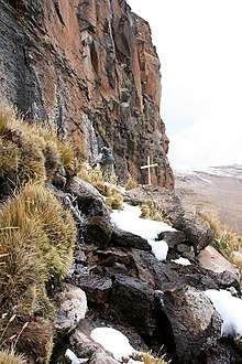
The next major expedition to search the Apurímac headwaters for the source of the Amazon was an expedition headed by Polish-born Jacek Palkiewicz and Peruvian Zaniel I. Novoa Goicochea in 1996. Palkiewicz and Novoa refuted the source identified by McIntyre in favor of a site at the headwaters of the Apacheta River. Their argument was that the Apacheta is a larger river than the Carhuasanta and is longer. They located the source of the Amazon at a small spring beneath a cliff watering a patch of vegetation 20 metres (66 ft) in diameter. The spring is located at -15.521 Latitude and -71.761 Longitude at an elevation of 5,182 metres (17,001 ft). It is about 5 kilometres (3.1 mi) from the Laguna Bohemia source.[16][17]
In 1999-2000, a Czech team headed by Bohumir Jansky identified the Carhuasanta River as the source of the Amazon. Later, in 2011, Jansky and his team published the results of a years-long study of the Apurímac headwaters. They described four short rivers, ranging in length from 8.1 kilometres (5.0 mi) to 13.1 kilometres (8.1 mi), which converge to form the Lloqueta river. The Carhuasanta River was the longest and had the largest drainage area of the four. They identified two sources of the Carhuasanta, including Laguna Bohemia. They did not offer an opinion in their 2011 study of the authentic source of the Amazon, although the Carhuasanta received the bulk of their attention.[18]
Also in 2011, the Peruvian government accepted the Apacheta River as the authentic source of the Amazon and unveiled a monument at the site.[19]
In 1955, there were six small glaciers in the area of the headwaters. By 2007, they had all disappeared with possible disruption to the flow of waters into the nearby rivers, and thus an impact on what might be considered the source of the Amazon.[20]
The Mantaro source
The confidence that the true source of the Amazon had been located in the upper waters of the Apurimac River was shaken in 2014 when James Contos and Nicholas Tripcevich advocated the Mantaro River as the most distant source of the Amazon. The traditionally-accepted source of the Mantaro is Lake Junin located at -10.998 Latitude and -76.109 Longitude. However, several streams feed into Lake Junin and Contos and Trepcevich followed them to their headwaters. They located the most distant source in the Rumi Cruz mountains with the coordinates of -10.732 Latitude and -76.648 Longitude at an elevation of 5,220 metres (17,130 ft). They also calculated the distance in river miles between the Apurimac River source (Mismi mountain) and the Mantaro River source to the junction of the two rivers. The Apurimac from source to mouth is 734.3 kilometres (456.3 mi) long and the Mantaro is 809 kilometres (503 mi) from source to mouth, thus making the total length of the Amazon 75 kilometres (47 mi) longer than previously calculated.[21]
Three sources of the Amazon
In their study of the Mantaro River, Contos and Tripcevich acknowledged that the flow of the river is interrupted several months a year by a water diversion project and thus a drop of water at its source may not complete the journey to the mouth of the Amazon. Thus, they proposed three sources of the Amazon: (1) the Marañón River is the "principal source' of the Amazon, because it carries the largest volume of water; (2) the Mantaro River is the "most distant source" of the Amazon; (3) the Apurímac River is the "most distant source of uninterrupted flow" of the Amazon.[22]
See also
- Source of the Nile River
References
- Contos, James and Tripcevich, Nicholas (2014), "Correct Placement of the most distant stream of the Amazon River in the Mantaro River Drainage," Wiley Online Library,, p. 38, , accessed 6 Oct 2018
- Google Earth
- "Ucayali River," Encyclopedia Britannica," , accessed 6 Oct 2018
- "Maranon River", Encyclopedia Britannica," , accessed 6 Oct 2018
- Loureiro Dias, Camila (July 2012), "Jesuit Maps and Political Discourse: The Amazon River of Father Samuel Fritz", The Americas, Vol 69, No. 9, p. 2014. Downloaded from Project Muse.
- Dasgupta, Shreya (2016), "Why the Source of the Amazon river remains a Mystery," BBC, , accessed 6 Nov 2018.
- Google Earth
- The State of Para: Notes for the Chicago Exposition, New York: G. P. Putnam's Sons, p. 44
- Google Earth
- "Sebastian Snow," (7 May 2001) The Telegraph, , accessed 6 Oct 2018.
- Google Earth
- Google Earth
- Janský, B., Engel, Z., Kocum, J., Šefrna, L. & Česák, J. (2011), "The Amazon River headstream area in the Cordillera Chila, Peru: hydrographical, hydrological and glaciological conditions," Hydrological Sciences Journal, Vol. 56, No. 1, p. 141.
- MacIntyre, Loren (Oct 1972), "Amazon: The River Sea," National Geographic Magazine.
- Google Earth
- , accessed 7 Oct 2018
- Google Earth
- Jansky et al, pp. 142-143
- Clarkson, Jeremy, "Monument at the Source of Amazon River,", Peruvian Times,, , accessed 7 Oct 2018
- Jansky, pp. 146-150
- Contos and Tripcevich, p. 35
- Contos and Tripcevich, p. 38