Songdalselva
Songdalselva or Søgneelva or Songa is a river in Agder county, Norway. The 55.3-kilometre (34.4 mi) long river in the hills between Finsland in Songdalen municipality and Hægeland in Vennesla municipality. The 209.4-square-kilometre (80.8 sq mi) catchment area is located between the Otra river and Mandalselva river watersheds. The river runs through the villages of Hortemo, Nodeland, Volleberg, Tangvall, Åros, and Høllen.
| Songdalselva Songa Søgneelva Sogna / Sygna | |
|---|---|
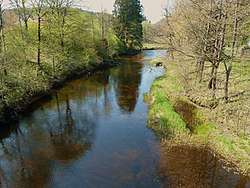 View of the river | |
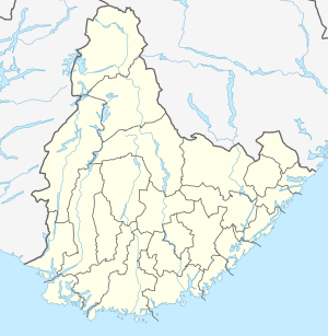 Location of the river  Songdalselva (Norway) | |
| Location | |
| Country | Norway |
| County | Agder |
| Municipalities | Søgne, Songdalen, Vennesla |
| Physical characteristics | |
| Source | |
| ⁃ location | Sognevannet, Songdalen/Vennesla |
| ⁃ coordinates | 58.3158°N 07.6725°E |
| ⁃ elevation | 311 metres (1,020 ft) |
| Mouth | |
⁃ location | Høllen, Søgne |
⁃ coordinates | 58.0762°N 07.8155°E |
⁃ elevation | 0 metres (0 ft) |
| Length | 55.3 km (34.4 mi) |
| Basin size | 209.4 km2 (80.8 sq mi) |
| Discharge | |
| ⁃ average | 6.25 m3/s (221 cu ft/s) |
| Basin features | |
| River system | Songdalen |
| Tributaries | |
| ⁃ right | Gumpedalselva |
The highest hills in the catchment area go up to 450 metres (1,480 ft) above sea level. The water flows are normally at their lowest in the summer and they're at their highest levels during the autumn and spring. There are only a few small lakes in the river system. The steep slopes down from the moors can create short and intense flood rapids. The river (here called Songa) flows through the Stallemodalen valley in Vennesla, and then falls into the Songdalen valley through a gorge at Underåsen.
Once in Songdalen, it is called the Songdalselva. Here it receives more water from the right from the Gumpedalselva tributary. The river drops no more than about 20-meter (66 ft) over the last 20-kilometer (12 mi) to the river mouth, and has on this stretch a very meandering run. There is a short waterfall (Søgne waterfall) near the Søgne Landbruksskole. From that waterfall to the sea, the river is called the Søgneelva.[1] The Songdalselva flows into the sea between the villages of Høllen and Åros in Søgne municipality.
Both salmon and sea trout are found in the river, and a fishing license is required for fishing along the river.
Environment
In the post-war years up until the 1980s, the river was thought of as an open sewer. Bathing and fishing were not recommended. Water quality improved by the time the sewer was led through pipes and cleansed before discharged to the sea. Today's (2016) environmental issue is mainly illegal garbage disposal and plastic waste from farming, accumulation along the banks and flowing into the ocean when the river is flooding.
In 1993, the watercourse was protected against hydropower development pursuant to Norwegian law, by development plans through Conservation Plan IV for waterways.[2]
Media gallery
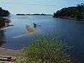 Søgneelva's mouth in Høllefjorden between Åros and Høllen.
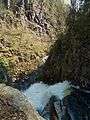 Songdalselva at the start of the gorge at Underåsen.
 Viewof the river in Søgne
References
- "Flomberegning for Søgneelva (022.1Z)" (PDF) (in Norwegian). Norwegian Water Resources and Energy Directorate. 2002. Cite journal requires
|journal=(help) - "022/1 Søgneelva" (in Norwegian). Norwegian Water Resources and Energy Directorate. 2016-06-28. Retrieved 2017-01-02.