Solander Islands
The Solander Islands (officially, Solander Islands/Hautere) are a small chain of uninhabited volcanic islets situated near the western end of the Foveaux Strait in southern New Zealand. The Māori name Hautere translates into English as "flying wind". The islands lie 38 km (24 mi) south of Prices Point on the southern coast of the South Island, close to where Lake Hakapoua drains through Big River to the Pacific Ocean due west of Te Waewae Bay, and 64 km (40 mi) northwest of the Putatara (Rugged) Point in the northwest of Stewart Island, or 56 km (35 mi) from Codfish Island west of Stewart Island. The islands measure 1.2 km2 (0.46 sq mi) in total area.[1] Administratively, they are part of Southland District.
| Maori: Hautere | |
|---|---|
 Overview map | |
| Geography | |
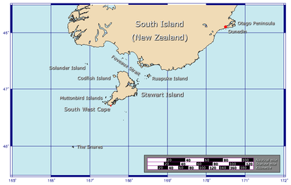
| Location | Southland District |
| Coordinates | |
| Area | 120 ha (300 acres) |
| Highest elevation | 330 m (1,080 ft) |
| Administration | |
The islands
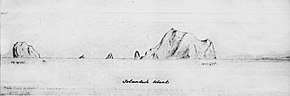
- Solander Island, the main island, covers around 1 km2 (0.39 sq mi) in area, rising steeply to a peak 330 metres (1,083 ft) above sea level. It is wooded with the exception of its northeast end, which appears as bare, white rock. There is a deep cave on the east side, Sealers Cave.
- Little Solander Island is 1.9 km (1.2 mi) west of the main island. It is 148 m (486 ft) high, with an area of 4 ha (9.9 acres). It has a barren appearance and is guano-covered.
- Pierced Rock is 250 m (273 yd) south of the main island. It rises to 54 m (177 ft) and measures just 2,000 m2 (22,000 sq ft) in area.
History
The island chain was sighted by Captain James Cook on 11 March 1770 and named by him after the Swedish naturalist Daniel Solander, one of the scientific crew aboard Cook's ship, Endeavour.[2]
The islands are geographically forbidding and weather conditions often confound the approach of ships. It is perhaps for this reason that the islands have only ever been briefly inhabited, and then only due to shipwreck or other marooning. Five men - four Europeans and one Australian aboriginal - were marooned there between 1808 and 1813, the longest continual period of habitation of the island group. They are thought to have been left ashore in two groups on two separate occasions to carry out sealing operations, but the sea state prevented the approach of any ship to recover them. In 1810, sealing traffic moved to Macquarie Island, farther to the west, and they were effectively abandoned. When they were rediscovered in 1813, it is likely that they had amassed a considerable number of dried seal pelts.[3][4]
Geology
The islands are remnants of an isolated extinct Pleistocene volcano with andesite rocks, one to two million years old. They lie on a bank with depths less than 100 m (328 ft), but are separated from the continental shelf around Foveaux Strait by a 4 km (2.5 mi) narrow trough with depths in excess of 200 m (656 ft) (at least 237 m or 778 ft). Therefore, the islands are included in the New Zealand Outlying Islands, despite their proximity to the mainland. The Solander Islands are the only New Zealand volcanic land features related to the subduction of the Australian Plate beneath the Pacific Plate.[5]
Flora and fauna
There are 53 vascular plant species, one third of which are very rare. The flora is dominated by ferns and orchids. The southern, and nominate, subspecies of Buller's albatross (Thalassarche b. bulleri) breeds only on the Solanders and the Snares.
The Solander Islands were historically a well-known area for migrating whales, especially southern right and sperm whales. Sperm whales in this area were said to be exceptionally large.[6]
Bird life
The islands are home to a variety of bird life.[7]
The Solander group has been identified as an Important Bird Area (IBA) by BirdLife International because of its significance as a breeding site for Buller's albatrosses (with about 5000 pairs) and common diving petrels.[8]
See also
- New Zealand outlying islands
- List of islands of New Zealand
- List of islands
- Desert island
References
- "Data Table - Protected Areas - LINZ Data Service (recorded area 120 ha)". Land Information New Zealand. Retrieved 27 August 2019.
- Lee, Garry J. "Science on the Map: Places in New Zealand Named After Scientists". The Rutherford Journal. Retrieved 20 April 2019.
- McNab, Robert (1905). Murihiku: A History of the South Island of New Zealand and the Islands Adjacent and Lying to the South, from 1642 to 1835. Cambridge University Press (republished 2011). p. 208-211. Retrieved 21 March 2019.
- McNab, Robert (2016). "MURIHIKU: A HISTORY OF THE SOUTH ISLAND OF NEW ZEALAND AND THE ISLANDS ADJACENT AND LYING TO THE SOUTH, FROM 1642 TO 1835 THE MYSTERY OF THE SOLANDERS, 1808–1813". 1905 Victoria University of Wellington. Retrieved 13 April 2019.
- Keith Lewis, Scott D. Nodder and Lionel Carter. 'Sea floor geology – Solander Island', Te Ara – the Encyclopedia of New Zealand. Updated 21 September 2007. Retrieved 29 March 2009.
- http://docs.niwa.co.nz/library/public/NIWAis76.pdf
- O'Donnell, Colin F.J. "Birds and mammals of Solander (Hautere) Island." Notornis 27: 21-44" (PDF). Notornis vol. 27). pp. 21--44.
- BirdLife International. (2012). Important Bird Areas factsheet: Solander Islands. Downloaded from http://www.birdlife.org on 27 January 2012.
- Wise's New Zealand guide: A gazetteer of New Zealand (4th ed.) (1969) Dunedin: H. Wise & Co. (N.Z.) Ltd.