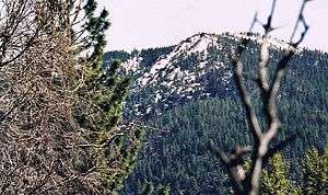
Snow Mountain East
Snow Mountain is a mountain in Northern California in the Snow Mountain Wilderness of Mendocino National Forest. The highest point on the mountain, known as Snow Mountain East, is the highest point in both Colusa and Lake counties. Snow Mountain West, a subsidiary peak also near the county line,[3] is 0.58 miles (0.93 km) to the southwest at an elevation of 7,043 feet (2,147 m).[4][5]

| Snow Mountain East | |
|---|---|
 | |
| Highest point | |
| Elevation | 7,055 ft (2,150 m) NAVD 88[1] |
| Prominence | 2,496 ft (761 m) [2] |
| Listing | California county high points 29th |
| Coordinates | 39°23′01″N 122°45′08″W [1] |
| Geography | |
| Location | Colusa and Lake counties, California, U.S. |
| Parent range | Pacific Coast Ranges |
| Topo map | USGS Crockett Peak |
On clear days, the peak should be seen from Mount Diablo, and from several peaks, including Mount Saint Helena and Mount Konocti, in the Mayacamas Mountains. The peaks are visible from Arbuckle on Interstate 5 in California's Central Valley.[6] The summits and nearby high mountains get snowfall in winter.[7] The mountain's winter snowpack can last until June.[6]
References
- "Snow Mountain East". NGS data sheet. U.S. National Geodetic Survey.
- "Snow Mountain, California". Peakbagger.com. Retrieved 2009-12-22.
- Crockett Peak quadrangle, California (Map). 1:24000. 7.5 Minute Topographic. USGS. Retrieved 2009-12-22.
- "Snow Mountain West". NGS data sheet. U.S. National Geodetic Survey.
- "Snow Mountain-West Peak, California". Peakbagger.com. Retrieved 2009-12-22.
- "Snow Mountain". SummitPost.org. Retrieved 2009-12-22.
- "Subsection M261Ba Eastern Franciscan". U.S. Forest Service. Archived from the original on 2009-01-20. Retrieved 2014-02-22.