Snake River (Colorado)
The Snake River is a short tributary of the Blue River, approximately 15 miles (24 km) long, in central Colorado in the United States. It drains a mountainous area on the west side of the Front Range in southeastern Summit County east of Keystone.
| Snake River | |
|---|---|
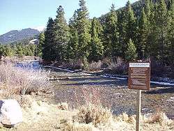 Snake River near Keystone | |
| Physical characteristics | |
| Source | |
| • location | Summit County, Colorado |
| • coordinates | 39°32′01″N 105°51′16″W |
| Mouth | Dillon Reservoir |
• location | Confluence with Blue at Dillon Reservoir |
• coordinates | 39°36′55″N 106°03′15″W[1] |
• elevation | 9,022 ft (2,750 m) |
| Length | 15 mi (24 km) |
| Basin features | |
| Tributaries | |
| • left | Deer Creek, Soda Creek |
| • right | North Fork Snake River |
It rises near the continental divide near Webster Pass along the Summit-Park county line and descends through a steep canyon to the north past the former mining camp of Montezuma, then turns west to flow past Keystone, where it joins the Blue from the east as an arm of Dillon Reservoir.
References
- "Snake River". Geographic Names Information System. United States Geological Survey. Retrieved 2011-01-26.
This article is issued from Wikipedia. The text is licensed under Creative Commons - Attribution - Sharealike. Additional terms may apply for the media files.