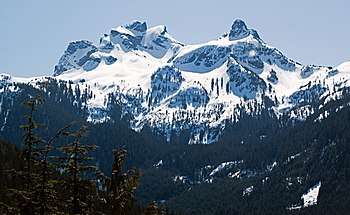
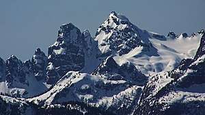
Sky Pilot Mountain (British Columbia)
Sky Pilot Mountain is a mountain in British Columbia in Canada. The mountain, and Sky Pilot Rock near Desolation Sound are named for the United Church's mission boat Sky Pilot.[3]:248
| Sky Pilot Mountain | |
|---|---|
 | |
| Highest point | |
| Elevation | 2,031 m (6,663 ft) [1] |
| Prominence | 1,236 m (4,055 ft) [1] |
| Parent peak | Mamquam Mountain |
| Coordinates | 49°38′05″N 123°05′11″W [2] |
| Geography | |
 Sky Pilot Mountain Location within British Columbia  Sky Pilot Mountain Sky Pilot Mountain (Canada) | |
| Location | British Columbia, Canada |
| Parent range | Britannia Range |
| Climbing | |
| Easiest route | South ridge |
Climate
Based on the Köppen climate classification, Sky Pilot is located in the marine west coast climate zone of western North America.[4] Most weather fronts originate in the Pacific Ocean, and travel east toward the Coast Mountains where they are forced upward by the range (Orographic lift), causing them to drop their moisture in the form of rain or snowfall. As a result, the Coast Mountains experience high precipitation, especially during the winter months in the form of snowfall. The months July through September offer the most favorable weather for climbing Sky Pilot.
References
- "Sky Pilot Mountain". Bivouac.com. Retrieved December 1, 2014.
- "Sky Pilot Mountain". BC Geographical Names. Provincial government of British Columbia. Retrieved December 1, 2014.
- Akrigg, G.P.V.; Akrigg, Helen B. (1986), British Columbia Place Names (3rd, 1997 ed.), Vancouver: UBC Press, ISBN 0-7748-0636-2
- Peel, M. C.; Finlayson, B. L. & McMahon, T. A. (2007). "Updated world map of the Köppen−Geiger climate classification". Hydrol. Earth Syst. Sci. 11. ISSN 1027-5606.