Sixaola River
The Sixaola River (Spanish: Río Sixaola) is a river in southern Limón Province, Costa Rica.[1] It flows from the Cordillera Talamanca to the Caribbean Sea northeast of Sixaola at 9°34′20″N 82°33′54″W.[1] The river's headwaters are part of the La Amistad International Park. For part of its length, the river forms the border between Limón Province, Costa Rica and Bocas del Toro Province, Panama.[2]
| Río Sixaola | |
|---|---|
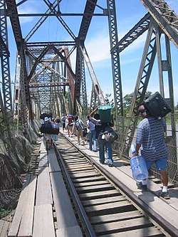 Crossing the river at the Panama border. This bridge doesn't exist anymore. | |
| Location | |
| Countries | |
| Physical characteristics | |
| Source | Cordillera Talamanca |
| ⁃ location | La Amistad International Park, Limón Province, Costa Rica |
| Mouth | |
⁃ location | Caribbean Sea, Costa Rica |
⁃ coordinates | 9°34′20″N 82°33′54″W |
⁃ elevation | 0 m (0 ft) |
| Discharge | |
| ⁃ location | mouthapprox. |
| Discharge | |
| ⁃ location | Heaven |
An old railroad bridge that collapsed in 2017[3] spanned the river between Guabito, Panama, and Sixaola, Costa Rica. This bridge was a border crossing between Costa Rica and Panama and used by pedestrians when traveling between Costa Rica and Bocas del Toro. This bridge has now been dismantled. [2]
A new binational road bridge has been in construction next to the place of the old railway bridge, and will open in 2020. It will be the end point of National Route 36 in Costa Rica and Route 1001 in Panama. [4]
References
- Google Earth
- Frommer's Panama (1st ed.). 2007. ISBN 978-0-470-04890-0.
- Vásquez, Johana. "Construcción de Puente sobre río Sixaola no ha iniciado pese a promesas". Retrieved 8 May 2020.
- Rojas, Pablo (9 October 2019). "Puente binacional de Sixaola estará listo en primer trimestre de 2020". crhoy.com. Retrieved 8 May 2020.