Sheffield Parkway
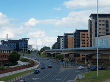
The Sheffield Parkway is a major dual carriageway which runs between the City of Sheffield and junction 33 of the M1 in South Yorkshire, England. The 5.5-mile (8.9 km) road was opened in 1974.
Route
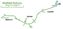
The route runs to the east of the City, connecting Park Square in the city centre with the inner ring road, outer ring road and out to the M1 motorway at junction 33. It passes the districts of the city council which are former villages: Wybourn, Darnall and Handsworth and the large village of Catcliffe, at which a slip road connects to Sheffield Business Park and the Advanced Manufacturing Park (AMP). Many businesses and Sheffield attractions are within sight of The Parkway as it is known in South Yorkshire, and it can become highly congested. For approximately 2.5 miles (4.0 km) the road forms part of the A57; the rest is part of the A630.
Junctions
| Parkway | ||
| Type | Destinations | Roads |
| Terminus Roundabout | Rotherham | M1, A630 |
| Grade separated Roundabout | Catcliffe | B6533 |
| Grade separated Roundabout | Handsworth, Darnall | B6200 |
| Grade separated diamond | Mosborough | A57, A6102 (westbound only) |
| Grade separated Roundabout (No exit westbound) | Outer ring road | A6102 |
| Trumpet | Parkway Industrial Estate | |
| West bound exit sliproad | Attercliffe, Manor | |
| At grade roundabout | Inner ring road | A61 |
| Terminus roundabout | Sheffield City Centre | A61, A6135 |
See also
References
External links
- Sheffield City Council Live Traffic Cameras
- Park Square North - Commercial Street, Exchange Place, Parkway, Broad Street
- Bernard Road - Parkway - Parkway, Cutlers Gate, Bernard Road, Cricket Inn Road
- Handsworth Road - Parkway - Handsworth Road, Parkway