Shōbōji Kofun
The Shōbōji Kofun (正法寺古墳, Shōbōji Kofun) is a Kofun period burial mound, located in what is now part of the city of Nishio, Aichi in the Tōkai region of Japan and were collectively designated a National Historic Site of Japan in 1957.[1]
正法寺古墳 | |
 Shōbōji Kofun | |
 Shōbōji Kofun  Shōbōji Kofun (Japan) | |
| Location | Nishio, Aichi, Japan |
|---|---|
| Region | Tōkai region |
| Coordinates | 34°47′23″N 137°05′07″E |
| History | |
| Periods | Kofun period |
| Site notes | |
| Ownership | National Historic Site |
| Public access | Yes |
Overview
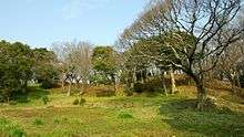
The kofun is located near the mouth of the Yahagi River facing Mikawa Bay in central Aichi Prefecture, on what was once a peninsula that extended about 400 meters east from an independent hill at an altitude of 115 meters in the former town of Kira. The coastline during the Kofun period is estimated to have reached about 10 kilometers inland from the present site; however, from ancient and medieval times land reclamation gradually progressed due to sedimentation of the Yahagi River. The hills within 2 kilometers around the old burial mound are formed of gabbro, and the stones covering the kofun are almost entirely gabbroic. The soil around the burial mound is reddish brown clay, which is due to the iron content of gabbro.
The name of "Shōbōji" refers to a Shingon sect temple built by the Ashikaga clan in the early Muromachi period and converted to the Sōtō sect during the Edo period. The hill was covered in pine forest during the Edo period and was not recognized as a kofun until after the start of the twentieth century. It was designated as a park in the 1930s, but as severely damaged by the Isewan Typhoon in 1959. The site was abandoned and overgrown for many years until the park was revived in 1989 and the dimensions of the kofun surveyed. Although the burial chamber was not opened, a total of 11 trenches were excavated in its sides from 1985 to 2002.
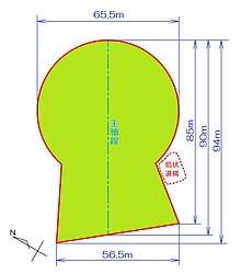
Per the 2001 and 2002 survey, the mound was established to be a three-tiered keyhole-shaped mound; however, with the front line is oblique to the main axis. This lack of symmetry was due to the contour of a natural hill, which was incorporated into the tumulus. The first and second ties were formed by cutting and contouring the natural hill, and the uppermost level was added as an embankment. The total length of the kofun is 94 meters with a 65.5 meter diameter circular portion. The height varies from location to location with a maximum of 28.8 meters.
Numerous cylindrical haniwa have been uncovered at the site (although none in situ, and none with any decoration) as well as numerous Sue ware pottery shards. The haniwa date the kofun to the late 4th to early 5th century.
References
- "Aichi Cultural Properties Navi" (in Japanese). Aichi Prefecture].
External links
| Wikimedia Commons has media related to Shoboji Kofun (Nishio). |