Serra de l'Espina
Serra de l'Espina is a limestone mountain chain located at the north-eastern end of the Iberian System. It connects the Ports de Tortosa-Beseit mountain massif with the Catalan Pre-Coastal Range.[1]
| Serra de l'Espina | |
|---|---|
 Serra de l'Espina rising above Alfara de Carles | |
| Highest point | |
| Peak | L'Espina |
| Elevation | 1,181.6 m (3,877 ft) |
| Coordinates | 40°52′46.73″N 0°21′43.93″E |
| Geography | |
 Serra de l'Espina Location in Catalonia | |
| Location | Baix Ebre |
| Parent range | Ports de Tortosa-Beseit |
| Geology | |
| Orogeny | Alpine orogeny |
| Type of rock | Karstic |
| Climbing | |
| Easiest route | Walk from Alfara de Carles |

Geography
The Serra de l'Espina ridge's highest point is L'Espina (1,181.6 m).[2] Other high peaks are Mola Carrascosa (1.025 m), Cap de la Faixa Blanca (1.023 m), Tossal de Montclí (960 m) and La Moleta d'Alfara (812 m).
On the eastern side of the range are some visible barren patches, devoid of vegetation owing to high winds, the very large Rases del Maraco, or Les Rases, at the southern end and Erms de Canduca further north. Other noteworthy places are Solana de les Feixes, the Cova dels Adells karstic cave and the ruins of Mas del Roig, an ancient farmhouse.
The Serra de Paüls mountain range is located to the north of this range.
Features
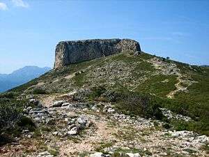 View of strikingly-shaped La Moleta
 The barren Rases del Maraco

See also
References
- Ports de Beseit
- "Mapa Topogràfic de Catalunya". Institut Cartogràfic de Catalunya. Retrieved 9 September 2010.
External links

- UEC - Guia itineraria dels Ports
- UEC Tortosa