Senio
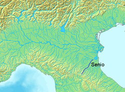
The Senio is a 92-kilometre (57 mi) river of Romagna in Italy, the final right-sided tributary of the river Reno. The source of the river is in the province of Florence in the Appennino Tosco-Emiliano mountains. The river flows northeast into the province of Ravenna and flows near Casola Valsenio, Riolo Terme, Castel Bolognese, Cotignola, Lugo, Bagnacavallo, Fusignano and Alfonsine before entering the Reno.[1] The river has a tributary called the Sintria that flows into it east of Riolo Terme. The river is along the road to Imola.
| Senio | |
|---|---|
 | |
| Location | |
| Country | Italy |
| Physical characteristics | |
| Source | |
| • location | Poggio dell'Altella |
| • elevation | about 900 m (3,000 ft) |
| Mouth | Reno |
• coordinates | 44.5475°N 12.0954°E |
| Length | 92 km (57 mi) |
| Basin size | about 450 km2 (170 sq mi) |
| Discharge | |
| • average | 10 m3/s (350 cu ft/s) |
| Basin features | |
| Progression | Reno→ Adriatic Sea |
The mean discharge at its mouth is about 10 cubic metres per second (350 cu ft/s); however this can vary from a minimum of 0.3 cubic metres per second (11 cu ft/s) to a maximum of 500 cubic metres per second (18,000 cu ft/s).
World War Two
The area was the site of several hard-fought battles in the Spring of 1945, during the last phases of World War II in Europe. The Allied crossing of the River Senio was one of the last hurdles that needed to be overcome in order to capture the great Po Valley basin and so complete the campaign in Italy. The German defenders were mostly elite parachute units and, in the very last days of war in Europe, the British 8th Army took many casualties in effecting this defended river-crossing operation.
References
- The Times Comprehensive Atlas of the World (13 ed.). London: Times Books. 2011. p. 76 M6. ISBN 9780007419135.
External links
- "World War II Engagements at the Senio River". Archived from the original on 2012-07-28.