Seithur
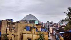
Seithur is a selection grade (selection grade) panchayat town in Rajapalayam taluk, Virudhunagar district in the Indian state of Tamil Nadu. Located in the Rajapalayam to Tenkasi NH208 Highway. Nature around western ghats due to greenish. Here there are many attractions near Seithur. Only 65 km to Courtallam, and only 5 km to Sasthakovil river.
Seithur | |
|---|---|
city | |
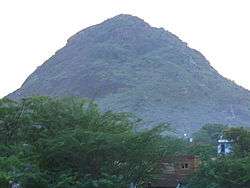 Koomatchi Malai, Seithur | |
 Seithur Location in Tamil Nadu, India | |
| Coordinates: 9°24′27″N 77°27′14″E | |
| Country | |
| State | Virudhunagar |
| Population (2001) | |
| • Total | 18,193 |
| Languages | |
| • Official | Tamil |
| Time zone | UTC+5:30 (IST) |
| PIN | 626121 |
Demographics
As of 2001 India census,[1] Seithur had a population of 18,012. Males constitute 49% of the population and females 51%. Seithur has an average literacy rate of 82% greater than the national average of 59.5%: male literacy is 88%, and female literacy is 77%. In Seithur, 11% of the population is under 6 years of age. There are many nursery and primary schools and a government higher secondary school, Government hospital,2 police stations inter police station and outer police station, SUB-REGISTRAR office that is head for nearest 18 villages and a famous sivan temple namely Thirukkanneeswarar are located in this village. Agriculture is the major occupation of this village (e.g.) paddy, cotton, coconut, sugarcane etc. 2014-2015 drought of rain fall very fall under ground water table very low. Mainly agriculture is our demand of native pride. Seria trade name is old culture.
But some persons do works like tailoring, working in mills etc. Srinivasaperumal with sridevi, poodevi, and Aanjanear temple is also located in outer stop.
The Maravar Zamindar Of Seithur - see The Aristocracy of Southern India - Mr.raja Rama Sevuka pandiya thevar. one among the 32 Marvar zamin in the Tirunelveli Zilla (Tirunelveli, Tenkasi and Thoothukudi District ) and Ramnad Zillas (Ramanathapuram, Sivagangai and Virudhunagar District)
Seithur Zamin
Seithur was ruled by Seithur Sevugapandiya. seithur zamin having control limit of 50 sq.kilometers radius. having own palace of about 50 acres. It's having control to rule whole virudhunagar district once ago.
References
- "Census of India 2001: Data from the 2001 Census, including cities, villages and towns (Provisional)". Census Commission of India. Archived from the original on 16 June 2004. Retrieved 1 November 2008.