Seiser Alm
Seiser Alm (Italian: Alpe di Siusi, Ladin: Mont Sëuc) is a Dolomite plateau and the largest high-altitude Alpine meadow (German: Alm) in Europe. Located in Italy's South Tyrol province in the Dolomites mountain range, it is a major tourist attraction, notably for skiing and hiking.
| Seiser Alm | |
|---|---|
| Alpe di Siusi | |
 Seiser Alm with the mountains of Langkofel Group in the background. | |
 Seiser Alm Location of Seiser Alm in Northern Italy 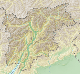 Seiser Alm Seiser Alm (Trentino-Alto Adige/Südtirol) | |
| Floor elevation | 1,700 m (5,600 ft) |
| Area | 52 km2 (20 sq mi) |
| Geography | |
| Country | Italy |
| State/Province | Trentino-Alto Adige |
| Population center | Bolzano |
| Coordinates | 46°32′28″N 11°38′40.99″E |
Geography
It is located in the western part of the Dolomites and has an altitude between 1,680 m a.s.l. and 2,350 m a.s.l.; it extends for 52 km² between Val Gardena to the north, the Sassolungo Group to the north-east and the Sciliar massif to the south-east, which with its unmistakable profile is one of the most famous symbols of all the Dolomites. Given the vastness of the area, from here it is possible to admire a large number of mountain groups: among others, the Sella Group, the Rosengarten group and the Marmolada.
It is an alp, it is an area where pasture is practiced, the largest in Europe, divided into numerous plots reserved to grazing or from which the farmers get hay for their farms located downstream.
The eastern part has been included since 1975 in the Sciliar natural park.
Surrounding peaks
The alp offers a panoramic view which includes (from north, in a clockwise direction): Peitlerkofel (Sass de Putia, 2,873 m), the Odle and the Puez groups (3,025 m), the Gran Cir, the Sella group (3,152 m), Langkofel (Sassolungo, 3,181 m) and Plattkofel (Sassopiatto, 2,995 m), the Marmolada (3.343 m), the Pala group (Pale di San Martino, 3,192 m), the Vajolet Towers (2,821 m) the Rosengarten group (Catinaccio, 2,981 m) with the peak of the Kesselkogel (Catinaccio d'Antermoia, 3,002 m) and the Schlern (Sciliar, 2,450 m).

Classification
The SOIUSA system considers the plateau as an alpine group with the following classification:
- Main part: Eastern Alps
- Major sector: South-Eastern Alps
- Section: Dolomites
- Subsection: North-Western Dolomites
- Supergroup: Gardena's Dolomites
- Group: Seiser Alp Group
- Code: II/C-31. III-A.3
It also attributes to the plateau the three following subgroups:
- Subgroup A: Palancia-Cresta di Siusi ridge
- Subgroup B: Dorsal Denti di Terra Rossa-Punta d'Oro-Piz ridge
- Subgroup C: Dorsal Bulacia-Salames-Col di Rende ridge
 Langkofel Group (Italian: Gruppo del Sassolongo) seen from Seiser Alm during winter.
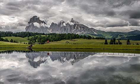 View from the plateau
Further reading
- Alberti, Alberto (1975). "Sodium-rich dachiardite from Alpe di Siusi, Italy". Contributions to Mineralogy and Petrology. 49 (1): 63–6. Bibcode:1975CoMP...49...63A. doi:10.1007/BF00371079.
- Keim, Lorenz (2008). "Geologie im Gebiet Schlern-Seiser Alm: vom Tethysmeer zum Gebirge" [Geology in the Schleern-Seiser Alm area: from the Tethyan Sea to mountain building]. Gredleriana (in German). 8: 25–46. Archived from the original on 2016-06-26.
External links
![]()