Seafloor mapping
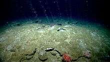
Seafloor mapping, also called seabed imaging, is the measurement of water depth of a given body of water. Bathymetric measurements are conducted with various methods, from sonar and Lidar techniques to buoys and satellite altimetry. Various methods have advantages and disadvantages and the specific method used depends upon the scale of the area under study, financial means, desired measurement accuracy, and additional variables. Despite modern computer-based research, the ocean seabed in many locations is less measured than the topography of Mars.[1]
History of seafloor mapping
The earliest methods of depth measurement on record are the use of sounding poles and weighted lines, recorded from Egypt more than 3000 years ago, and in use without significant improvement until the voyage of HMS Challenger in the 1870s, when similar systems using wires and a winch were used for measuring much greater depths than previously possible, but this remained a one depth at a time procedure which required very low speed for accuracy.[2]
At the beginning of the twentieth century mapping the seafloor was a very difficult task. The mapping of the sea floor started by using sound waves, contoured into isobaths and early bathymetric charts of shelf topography. These provided the first insight into seafloor morphology, though mistakes were made due to horizontal positional accuracy and imprecise depths. In 1957, Marie Tharp, working alongside with Bruce Charles Heezen created the first three-dimensional physiographic map of the world's ocean basins.
Tharp's discovery was made at the perfect time. It was one of many discoveries that took place near the same time as the invention of the computer. Computers, with their ability to compute large quantities of data, have made research much easier, include the research of the world's oceans.
There has been a boom in the underwater environmental exploration; rather than simply creating a map, scientists are attempting to visualize the entire seafloor with maximum possible detail. Computers are put to good use here with their help, researchers have managed to store and analyze large quantities of data. This led to the creation of the first digital map of the world ocean bed in 1970. Constantly developing technology allows computing to take place in the special equipment required for "high-resolution orthoimagery". This means researchers may no longer need to use sound frequencies to conduct marine exploration.
This method was later upgraded to Airborne Laser Bathymetry (ALB). ALB provides images that are both higher quality and in color.. The improvements to these research methods and the large amount of data received, stored and computed all led to the creation of one of the first color images of the underwater environment created on a computer.[3]
Satellite imagery
Introduction
Another form of mapping the seafloor is through the utilisation of satellites. The satellites are equipped with hyper-spectral and multi-spectral sensors which are used to provide constant streams of images of coastal areas providing a more feasible method of visualising the bottom of the seabed.[4]
Hyper-spectral sensors
The data-sets produced by Hyper-Spectral (HS) Sensors tend to range between 100-200 spectral bands of approximately 5 - 10 nm bandwidths. Hyper-Spectral Sensing, or imaging spectroscopy, is a combination of continuous remote imaging and spectroscopy producing a single set of data.[4] Two examples of this kind of sensing are AVIRIS (Airborne visible/infrared imaging spectrometer) and HYPERION. More information on Hyper-Spectral Imaging can be found here (Hyperspectral imaging).
The application of HS sensors in regards to the imaging of the seafloor is the detection and monitoring of chlorophyll, phytoplankton, salinity, water quality, dissolved organic materials, and suspended sediments. However this does not provide a great visual interpretation of coastal environments.[4]
Multi-spectral sensors
The other method of satellite imaging, multi-spectral (MS) imaging, tends to divide the EM spectrum into a small number of bands, unlike its partner Hyper-Spectral Sensors which can capture a much larger number of spectral bands. More information on multi-spectral sensing can be found at Multispectral image.
MS sensing is used more in the mapping of the seabed due to its fewer spectral bands with relatively larger bandwidths. The larger bandwidths allow for a larger spectral coverage, which is crucial in the visual detection of marine features and general spectral resolution of the images acquired.[4]
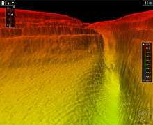
Airborne laser bathymetry
Introduction
High-density airborne laser bathymetry (ALB) is a modern, highly technical, approach to the mapping the seafloor. First developed in the 1960s and 1970s, ALB is a "light detection and ranging (LiDAR) technique that uses visible, ultraviolet, and near infrared light to optically remote sense a contour target through both an active and passive system." What this means is that airborne laser bathymetry uses light outwith the visible spectrum to detect the curves in underwater landscape.[4]
LiDAR
LiDAR, an acronym meaning Light Detection And Ranging, is, according to the National Oceanic and Atmospheric Administration, "a remote sensing method that uses light in the form of a pulsed laser to measure distances".[5]
These light pulses, along with other data, generate a three-dimensional representation of whatever the light pulses reflect off, giving an accurate representation of the surface characteristics. A LiDAR system usually consists of a laser, scanner, and GPS receiver. Airplanes and helicopters are the most commonly used platforms for acquiring LIDAR data over broad areas. One application of LiDAR is bathymetric LiDAR, which uses water-penetrating green light to also measure seafloor and riverbed elevations.[5]
Execution
ALB generally operates in the form of a pulse of non-visible light being emitted from a low-flying aircraft and a receiver recording two reflections from the water. The first of which originates from the surface of the water, and the second from the seabed. This method has been used in a number of studies to map segments of the seafloor of various coastal areas.[6][7][8]
Examples of commercial LIDAR bathymetry systems
There are various LIDAR Bathymetry Systems that are commercially accessible. Two of these systems are the Scanning Hydrographic Operational Airborne Lidar Survey (SHOALS) and the Laser Airborne Depth Sounder (LADS). SHOALS was first developed to help the United States Army Corps of Engineers (USACE) in bathymetric surveying by a company called Optech in the 90s. SHOALS is done through the transmission of a laser, of wavelength between 530 and 532 nm, from a height of approximately 200 m at speed of 60 m/s on average.[9]
High resolution orthoimagery
High resolution orthoimagery (HRO) is the process of creating an image that combines the geometric qualities with the characteristics of photographs. The result of this process is an orthoimage, a scale image which includes corrections made for feature displacement such as building tilt. These corrections are made through the use of a mathematical equation, information on sensor calibration, and the application of digital elevation models.[10]
Execution of HRO
An orthoimage can be created through the combination of a number of photos of the same target. The target is photographed from a number of different angles to allow for the perception of the true elevation and tilting of the object. This gives the viewer an accurate perception of the target area.[10]
Use in seafloor mapping
High resolution orthoimagery is currently being used in the 'terrestrial mapping program', the aim of which is to 'produce high resolution topography data from Oregon to Mexico'. The orthoimagery will be used to provide the photographic data for these regions.[11]
Seabed 2030 Project
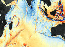
The Nippon Foundation-GEBCO Seabed 2030 Project, which aims to motivate a number of collaborators to create a full map of the ocean floor, was launched in 2016.[12] There are four Seabed 2030 centres, which coordinate mapping activities in different regions, gather and compile the bathymetric information, and partner with existing mapping activities within their regions. The Seabed 2030 Global Center is responsible for "producing and delivering global GEBCO products".[13]
GEBCO stands for General Bathymetric Chart of the Oceans. It is the only intergovernmental body with a mandate to map the whole ocean floor. At the beginning of the project, only 6 per cent of the world's ocean bottom had been surveyed to today's standards; as of June 2020, the project had recorded 19 per cent mapped. About 14,500,000 square kilometres (5,600,000 sq mi) of new bathymetric data was included in the GEBCO grid in 2019. Satellite technology, using altimeters that infer seafloor topography from the way its gravity affects the surface of the ocean above it, but it does not give a sufficiently high resolution. Seabed 2030 aims to achieve a resolution of at least 100m over every part of the ocean floor.[12]
Governments, institutions and companies have been contributing to the effort, and Seabed 2030 is crowdsourcing information from any party that is able to contribute, including small boats. The British Antarctic Survey is assisting the effort by varying the routes of its boats in order to map different parts of the sea floor.[12]
See also
References
- Jones, E.J.W. (1999). Marine geophhysics. New York: Wiley.
- Wölfl, Anne-Cathrin; Snaith, Helen; Amirebrahimi, Sam; Devey, Colin W.; Dorschel, Boris; Ferrini, Vicki; Huvenne, Veerle A. I.; Jakobsson, Martin; Jencks, Jennifer; Johnston, Gordon; Lamarche, Geoffroy; Mayer, Larry; Millar, David; Pedersen, Terje Haga; Picard, Kim; Reitz, Anja; Schmitt, Thierry; Visbeck, Martin; Weatherall, Pauline; Wigley, Rochelle (2019). "Seafloor Mapping – The Challenge of a Truly Global Ocean Bathymetry". Frontiers in Marine Science. 6: 283. doi:10.3389/fmars.2019.00283. ISSN 2296-7745.
- Charles W. Finkl, 2016, Seafloor Mapping Along Continental Shelves: Research and Techniques for Visualizing Benthic Environments. Internet resource edition. Volume 13. Page(s) 3 - 53
- Charles W. Finkl, ed., 2016, Seafloor Mapping Along Continental Shelves: Research and Techniques for Visualizing Benthic Environments. Internet resource edition. Volume 13. Page(s) 31 - 35
- National Oceanic and Atmospheric Administration (NOAA) (15 April 2020). "What is LIDAR?". NOAA's National Ocean Service. Retrieved 21 June 2020.
- Brock & Purkis (2009) The emerging role of Lidar remote sensing in coastal research and resource management. In: Brock J, Purkis S (eds) Coastal applications of airborne lidar. J Coastal Res, Special Issue No. 53: Page(s) 1–5
- Bukata et al. (1995) Optical properties and remote sensing of inland and coastal waters. CRC Press, Boca Raton, pages 365
- Deronde et al. (2008) Monitoring of the sediment dynamics along a sandy shoreline by means of airborne hyper-spectral remote sensing and LIDAR: a case study in Belgium. Earth Surf Process 33: Page(s) 280–294
- Charles W. Finkl, ed., 2016, Seafloor Mapping Along Continental Shelves: Research and Techniques for Visualizing Benthic Environments. Internet resource edition. Volume 13. Page 23
- USGS, Date Last Edited 2015, High Resolution Orthoimagery (HRO), https://lta.cr.usgs.gov/high_res_ortho
- State of California Ocean Protection Council, 2009, Mapping California's Resources,http://www.opc.ca.gov/2009/12/mapping/
- Amos, Jonathan (21 June 2020). "One-fifth of Earth's ocean floor is now mapped". BBC News. Retrieved 21 June 2020.
- "Data centers for the Nippon Foundation-GEBCO Seabed 2030 Project". Nippon Foundation-GEBCO Seabed 2030 Project. GEBCO. Retrieved 21 June 2020.