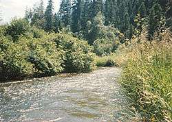
Sanpoil River
The Sanpoil River (also spelled San Poil) is a tributary of the Columbia River, in the U.S. state of Washington. The term Sanpoil is from the Okanagan term [snpʕʷílx], meaning "people of the gray country",[5] or "gray as far as one can see".[6]
| Sanpoil River | |
|---|---|
 | |
| Location | |
| Country | United States |
| State | Washington |
| City | Republic |
| Physical characteristics | |
| Source | |
| ⁃ coordinates | 48°38′54″N 118°38′12″W[1] |
| ⁃ elevation | 2,735 ft (834 m)[2] |
| Mouth | Columbia River |
⁃ coordinates | 47°56′55″N 118°40′50″W[1] |
⁃ elevation | 1,293 ft (394 m)[2] |
| Length | 70 mi (110 km)[3] |
| Basin size | 981 sq mi (2,540 km2)[4] |
| Basin features | |
| Tributaries | |
| ⁃ right | West Fork Sanpoil River |
- For other references, see Sanpoil (disambiguation).
Course
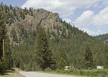
The Sanpoil River originates near the city of Republic, in the Okanagan Highland, east of the Okanogan River. It flows south through the Colville National Forest, Okanogan National Forest, and the Colville Indian Reservation. After entering the reservation the river receives its main tributary, the West Fork Sanpoil River. It then receives a number of smaller tributaries such as Twentyone Mile Creek, Twentythree Mile Creek, and Thirty Mile Creek.
The Sanpoil River enters Franklin D. Roosevelt Lake (FDR Lake), the impounded Columbia River above Grand Coulee Dam. The dam impounded the last few miles of the Sanpoil River as well. This part of FDR Lake is called Sanpoil Arm. Like many tributaries of the Columbia River, the Sanpoil River had a major salmon run before the river was dammed.[5]
Relatively low numbers of adfluvial wild rainbow trout and hatchery-released kokanee salmon return to the Sanpoil River from Lake Roosevelt. Smallmouth bass and walleye, two nonindigenous predators that stage at the river/lake interface during the juvenile migration season, are thought to consume large numbers of these species. To determine the percentage that were consumed, Stroud et al. (2010, 2011) used bioenergetic models linked to population estimates. They estimate that the predators consumed 105 (95% CI, 86-162)% of the 0.5–year kokanee salmon, 39 (33-68)% of the 1.5–year kokanee salmon, 74 (60-118)% of the 1–year rainbow trout and 53 (44-92)% of the 2 and 3–year old rainbow trout in a 113-day study window.
Habitats
- Mountain riparian
- Mixed forest
- Wetland
- Freshwater marsh
Birds
- Common loon
- Barrow’s goldeneye
- Golden and bald eagles
- Northern pygmy-owl
- Black-chinned, calliope, and rufous hummingbirds
- Lewis’s and pileated woodpeckers
- Red-naped sapsucker
- Hammond’s, dusky, and Pacific-slope flycatchers
- Cassin’s vireo
- Pygmy nuthatch
- Western bluebird
- Northern waterthrush
See also
| Wikimedia Commons has media related to Sanpoil River. |
- Tributaries of the Columbia River
- List of rivers of Washington
References
- U.S. Geological Survey Geographic Names Information System: Sanpoil River, USGS, GNIS
- Google Earth elevation for GNIS coordinates.
- Grande Ronde River, The Columbia Gazetteer of North America
- San Poil, Intermountain Province Plan, Northwest Power and Conservation Council
- Majors, Harry M. (1975). Exploring Washington. Van Winkle Publishing Co. p. 55. ISBN 978-0-918664-00-6.
- Bright, William (2004). Native American placenames of the United States. University of Oklahoma Press. p. 419. ISBN 978-0-8061-3598-4. Retrieved 6 April 2011.
Further reading
- Atwater, Brian F. Pleistocene Glacial-Lake Deposits of the Sanpoil River Valley, Northeastern Washington. U.S. Geological Survey bulletin, 1661. Washington: G.P.O., 1986.
- Atwater, Brian F. Guidebook for 1983 Friends of the Pleistocene Field Trip to the Sanpoil River Valley, Northeastern Washington. U.S. Geological Survey open-file report, 83-456. Menlo Park, CA: U.S. Geological Survey, 1983.
- Geological Survey (U.S.), and L. L. Bryan. Plan and Profile of Hall Creek, Mouth to Mile 4 and Dam Sites on Sanpoil River, Washington. [Washington, D.C.]: Dept. of the Interior, U.S. Geological Survey, 1930.
- Juul, Steve Thorvald Julius, et al. Nonpoint Pollution at the Headwaters of the Sanpoil River in Ferry County, Washington. Pullman, Wash: State of Washington Water Research Center, 1993.
- Pacific Northwest River Basins Commission. River Mile Index: Moses Coulee, Crab & Foster Creeks, Okanogan (Okanagan), Sanpoil, Colville & Kettle Rivers. [S.l.]: The Committee, 1968.
- Trotter, Patrick C. Genetic and Phenotype Catalog of Native Resident Trout of the Interior Columbia River Basin: FY-99 Report : Populations of the Pend Oreille, Kettle, and Sanpoil River Basins of Colville National Forest. [Portland, OR: Bonneville Power Administration, 2001.
External links
| Authority control |
|
|---|