Saline River (Little River tributary)
The Saline River is an 80-mile-long (130 km)[3] tributary of the Little River in southwestern Arkansas in the United States. Via the Little and Red rivers, it is part of the watershed of the Mississippi River.
| Saline River | |
|---|---|
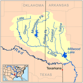 Map of the Little River watershed showing the Saline River | |
| Location | |
| Country | United States |
| State | Arkansas |
| Physical characteristics | |
| Source | |
| ⁃ location | Ouachita Mountains |
| ⁃ coordinates | 34°23′01″N 93°59′48″W[1] |
| ⁃ elevation | 259 feet (79 m) |
| Mouth | |
⁃ location | Millwood Lake, Little River |
⁃ coordinates | 33°43′54″N 93°58′06″W[1] |
| Length | 80 miles (130 km) |
| Discharge | |
| ⁃ location | Lockesburg, Arkansas [2] |
| ⁃ average | 390 cu/ft. per sec. |
It rises in the Ouachita Mountains in southeastern Polk County, in the Ouachita National Forest, and flows generally south through Howard County and along Howard County's boundary with Sevier County, through Dierks Lake, which is formed by a U.S. Army Corps of Engineers dam. It enters the Little River as part of Millwood Lake, which is formed by another USACE dam on the Little River.
See also
- List of Arkansas rivers
References
- Notes
- "Saline River". Geographic Names Information System. United States Geological Survey. Retrieved 2014-01-13.
- USGS water data
- "The National Map". U.S. Geological Survey. Retrieved March 8, 2011.
- Sources
- DeLorme (2004). Arkansas Atlas & Gazetteer. Yarmouth, Maine: DeLorme. ISBN 978-0-89933-345-8.
- The Encyclopedia of Arkansas History & Culture
External links
- "Dierks Lake website". Archived from the original on 2009-06-25. Retrieved 2006-02-21.
- Millwood Lake website
This article is issued from Wikipedia. The text is licensed under Creative Commons - Attribution - Sharealike. Additional terms may apply for the media files.