Saint-Hilaire, Isère
Saint-Hilaire, also known as Saint-Hilaire du Touvet (French pronunciation: [sɛ̃tilɛʁ dy tuvɛ]), is a former commune in the Isère department in southeastern France. On 1 January 2019, it was merged into the new commune Plateau-des-Petites-Roches.[2]
Saint-Hilaire | |
|---|---|
Part of Plateau-des-Petites-Roches | |
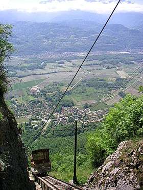 Funicular railroad | |
 Coat of arms | |
Location of Saint-Hilaire 
| |
 Saint-Hilaire  Saint-Hilaire | |
| Coordinates: 45°18′37″N 5°53′16″E | |
| Country | France |
| Region | Auvergne-Rhône-Alpes |
| Department | Isère |
| Arrondissement | Grenoble |
| Canton | Le Moyen Grésivaudan |
| Commune | Plateau-des-Petites-Roches |
| Area 1 | 9 km2 (3 sq mi) |
| Population (2017-01-01)[1] | 1,326 |
| • Density | 150/km2 (380/sq mi) |
| Time zone | UTC+01:00 (CET) |
| • Summer (DST) | UTC+02:00 (CEST) |
| Postal code | 38660 |
| Elevation | 647–2,060 m (2,123–6,759 ft) (avg. 1,000 m or 3,300 ft) |
| Website | https://sainthilairedutouvet.com |
| 1 French Land Register data, which excludes lakes, ponds, glaciers > 1 km2 (0.386 sq mi or 247 acres) and river estuaries. | |
It is made up of the three smaller settlements of Saint-Hilaire, Les Margains and Les Gaudes, and its inhabitants are called the Saint-Hilairois (Saint-Hilairoises).[3]
The commune is situated on the Plateau des Petites Roches, a natural balcony above the valley of the Isère River, on the east side of the Massif de la Chartreuse and overlooked by the peak of the Dent de Crolles.[3]
Saint-Hilaire is linked to Montfort, situated on the road between Grenoble and Chambéry in the valley below, by the Funiculaire de Saint-Hilaire du Touvet. Until this was opened in 1924, the village was accessible only on foot, or by mule. The funicular was constructed principally to serve several sanatoriums built at the same time to house tuberculosis patients.[4] A road has long since been opened, and the funicular is now used mostly by tourists and paragliders.
Population
| Historical population | |||||||||||||||||||||||||||||||||||||||||||||||||||||||||||||||||||||||||||||||
|---|---|---|---|---|---|---|---|---|---|---|---|---|---|---|---|---|---|---|---|---|---|---|---|---|---|---|---|---|---|---|---|---|---|---|---|---|---|---|---|---|---|---|---|---|---|---|---|---|---|---|---|---|---|---|---|---|---|---|---|---|---|---|---|---|---|---|---|---|---|---|---|---|---|---|---|---|---|---|---|
|
| ||||||||||||||||||||||||||||||||||||||||||||||||||||||||||||||||||||||||||||||
See also
References
- "Populations légales 2017". INSEE. Retrieved 6 January 2020.
- Arrêté préfectoral 18 December 2018 (in French)
- Based on a translation of the article from the French Wikipedia.
- "Funiculaire Saint Hilaire du Touvet - History". Funimag. Retrieved February 15, 2007.
| Wikimedia Commons has media related to Saint-Hilaire, Isère. |
| Authority control |
|
|---|