Saganaga Lake
Saganaga Lake is a large lake on the Minnesota – Ontario international border. It is protected by the Boundary Waters Canoe Area Wilderness in the United States and by Quetico Provincial Park and La Verendrye Provincial Park in Canada.
| Saganaga Lake | |
|---|---|
 Canoeists near Cache Bay | |
| Location | Ontario / Minnesota |
| Coordinates | 48°14′39″N 90°54′43″W |
| Type | glacial lake |
| Primary inflows | Saganaga Falls on the Granite River; Seagull River; Curran Bay from Northern Light Lake |
| Primary outflows | Silver Falls in Cache Bay |
| Basin countries | Canada, United States |
| Surface area | 13,832 acres (5,598 ha) |
| Max. depth | 280 ft (85 m) |
| Surface elevation | 1,430 ft (440 m) |
| Frozen | typically November to May |
| Islands | Campers Island, Connors Island, Horseshoe Island, Munker Island, many others |
| References | [1] |
It is both the deepest and largest lake in the Boundary Waters Canoe Area Wilderness with a maximum depth of 280 ft (85 m) and surface area of 13,832 acres (5,598 ha).[1]
Saganaga is a popular fishing destination, with northern pike, walleye, lake trout, smallmouth bass, and lake whitefish among others. Minnesota Department of Natural Resources has issued a consumption advisory for some fish in Saganaga Lake due to mercury pollution.[1] The Lake is the eastern boundary of the historical Hunter Island region. Saganaga Lake is bordered to the south by Seagull Lake, home to Wilderness Canoe Base.
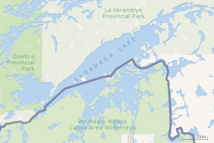 |
| Saganaga Lake, with the US/Canada border running through it. |
References
- "Lake Information Report". Minnesota Department of Natural Resources. Retrieved 2009-06-02.