Sabroom
Sabroom is a town and a nagar panchayat in South Tripura district in the Indian state of Tripura.
Sabroom | |
|---|---|
Town | |
 Sabroom  Sabroom | |
| Coordinates: 23.00°N 91.73°E | |
| Country | India |
| State | Tripura |
| District | South Tripura |
| Elevation | 26 m (85 ft) |
| Population (2001) | |
| • Total | 5,766 |
| Languages | |
| • Official | Bengali, Kokborok, English |
| Time zone | UTC+5:30 (IST) |
| Vehicle registration | TR |
| Website | tripura |
Sabroom is located in the banks of the Feni river, which separates India and Bangladesh. Most of the people speak in Noyakhali, a dialect of Bengali language.
Geography
Sabroom is located at 23.00°N 91.73°E.[1] It has an average elevation of 26 m (85 ft).
Demographics
As of 2001 India census,[2] Sabroom had a population of 5766. Males constitute 52% of the population and females 48%. Sabroom has an average literacy rate of 82%, higher than the national average of 59.5%: male literacy is 86%, and female literacy is 78%. In Sabroom, 11% of the population is under 6 years of age.
Politics
Sabroom assembly constituency is part of Tripura East (Lok Sabha constituency).[3]
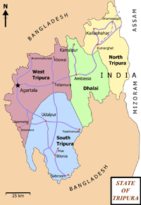
State of Tripura having 4 districts, roadways & small railway network.
See also
References
- Falling Rain Genomics, Inc - Sabroom
- "Census of India 2001: Data from the 2001 Census, including cities, villages and towns (Provisional)". Census Commission of India. Archived from the original on 16 June 2004. Retrieved 1 November 2008.
- "Assembly Constituencies - Corresponding Districts and Parliamentary Constituencies" (PDF). Tripura. Election Commission of India. Archived from the original (PDF) on 8 November 2005. Retrieved 8 October 2008.
This article is issued from Wikipedia. The text is licensed under Creative Commons - Attribution - Sharealike. Additional terms may apply for the media files.