Ryther cum Ossendyke
Ryther cum Ossendyke is a civil parish of 6 miles (9.7 km) from Tadcaster and 6 miles (9.7 km) from Selby, North Yorkshire, England. It includes the village of Ryther. The civil parish population at the 2011 census was 241.[1]
| Ryther cum Ossendyke | |
|---|---|
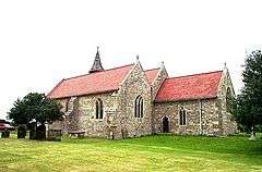 All Saints Church, Ryther | |
 Ryther cum Ossendyke Location within North Yorkshire | |
| Population | 241 (2011 census)[1] |
| Civil parish |
|
| District |
|
| Shire county | |
| Region | |
| Country | England |
| Sovereign state | United Kingdom |
| Post town | selby |
| Postcode district | LS24 |
| Dialling code | 01757 |
| Police | North Yorkshire |
| Fire | North Yorkshire |
| Ambulance | Yorkshire |
History
It originated as a parish in the wapentake of Barkston Ash in the West Riding of Yorkshire. The parish, bounded on the north by the River Wharfe, covered 1074 hectares and contained the township of Lead Hall about six miles away where there is St Mary's Chapel, a chapel of ease to All Saints Church.[2]
Ryther is the site of the 13th century All Saints Church, a Methodist chapel, public house (Rythre Arms) and village hall. It is adjacent to Nun Appleton Hall. From the 12th to the 16th century, the village was the site of Ryther Castle, the principal seat of the ancient de Rhythre/Ryther family, the Lords of Scarcroft who inherited Harewood Castle in about 1400. Several of the de Ryther knights have effigies at All Saints Church. The village once had several shops and many farms. Census returns show how many residents were farm labourers or had jobs in Cawood. There were two public houses, but only one remains.
The estate of Ryther was owned by the Barons Haversham, who bequeathed it to Thomas Corbett (Lincolnshire MP) in the 1830s.[3]
Geography
The hamlet is situated on the south bank of the River Wharfe and has often been at risk of flooding. Ossendyke ings are within the parish.
The hamlet of Ryther was a community with generations of the same families living close by. Ossendyke has few houses. Adjacent to Ossendyke is the Church Fenton Aerodrome which is used by small light aircraft and practising jets.
Ossendyke has had various spellings: Ozendyke - the modern spelling, Ossendyke, Ozendike and Ozzendyke
References
- UK Census (2001). "Local Area Report – Ryther cum Ossendyke Parish (E04007763)". Nomis. Office for National Statistics. Retrieved 12 June 2019.
- Lewis, Samuel (1848). Ryther (All Saints). A Topographical Dictionary of England. British History Online. pp. 719–725. Retrieved 18 October 2011.
- Burke, John (1838). A Genealogical and Heraldic History of the Landed Gentry; Or, Commoners of Great Britain and Ireland Etc. p. 191. Retrieved 3 April 2020.
External links
![]()