Rundēni Parish
Rundēni parish (Latvian: Rundēnu pagasts) is located in a southwest of Ludza District in Latvia, it borders on the Pildas, Nirza, Lauderu and Istras parishes (all: Ludza District), the Škaunes and Ezernieku parishes (both: Krāslava District) and the Kaunatas parish (Rezekne District). Distances: from parish centre - village of Rundēni up to District centre - Ludza is 33 km, up to the Capital of Latvia - Riga - 315 km.
 Village of Rundēni | |
| Country: | Latvia |
|---|---|
| Region: | Latgale |
| District: | Ludza District |
| Administrative centre: | Rundēni |
| Status: | from 1933 |
| Population: | 620 (2007) |
| Location: | 56°16′36.3″N 27°49′34.7″E |
Population and national structure
In the Census of 2000, from a population of 800, there were 231 residents of Latvian nationality, 522 Russians, and 23 Belarussians.
Relief
| Total area | The agricultural land | Woods | Infrastructure | Melioration | |
|---|---|---|---|---|---|
| 100.00% | 47.45% | 39.89% | 6,70% | 5,96% | |
| 12466,5 ha | 5915.9 ha | 4972,7 ha | 835,1 ha | 742.8 ha | |
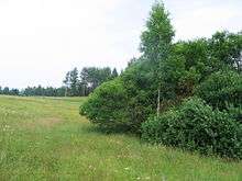
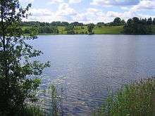
The Rundēni parish is located on the Height of Latgale. The most part of parish is covered by hills of Razna, in a southeast - by hills of Dagda. The highest part of Rundēni parish is a northern part, which forms a watershed between the rivers Daugava and Velikaya (basin of Lake Pskov). Also on a height there is a western part, which closely approaches to massif of Lielais Liepukalns. The highest hills are Pentjušu Hill, and also hills to the north from Kovaļiški at Sūnupļava and at Rudzīši. The biggest lake is Lake Bižas. Smaller lakes: Bezersļesjes, Aunejas, Testečkovas, Loboržu, Audeļu (Kovaļišku), Bļižņevas, Glušeņa, Pakalnu, Vorzovas, Kazeņa, Rudzīšu. On territory of parish flows the Saryanka River, which runs into Daugava. Other small rivers of the rural community: Kazeņa, Siņica, Volčica, Vonogupīte.
Villages and populated places
The centre of the parish is the village of Rundēni. Other populated places include:
- Adelinova
- Barsuki
- Bezlesje
- Bļižņeva
- Bori
- Bojari
- Briževa
- Bubinova
- Čuhnova
- Dvorišče
- Devjatņiki
- Drozdovka
- Dzenegaļi
- Gorodoks
- Greidani
- Griņkova
- Homutova
- Kabilovka
- Kazeņa
- Kazici
- Kannova
- Kļeščeva
- Klumstova
- Kovaļiški
- Ksaverina
- Labunščina
- Lielā Maļinovka
- Lisova
- Loborži
- Losiški
- Mazkrinica
- Maļinovka
- Mačuļi
- Mežavēpri
- Nalogi
- Noviņi
- Noviydvors
- Opši
- Osova
- Ostrova
- Pakalni
- Pentjuši
- Pereļji
- Pešleva
- Posiški
- Punculova
- Pušča
- Rocova
- Rudzīši
- Ruleva
- Rusecki
- Sarja
- Savina
- Stankeviči
- Strukaļi
- Sūnupļava
- Tarčilova
- Tartaks
- Tereneva
- Testečkova
- Škorlupova
- Yačmenišče
- Vertulova
- Zamostje
- Zarečje
- Zirgi
- Zubova
- Žubuļi
Economic activities
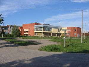
Under direction of self-management of Rundēni parish there are the following establishments located in the parish centre: school (does not work since 2007), a preschool educational institution, the People's house (club), dispensary and library. The largest farms of Rundēni parish: 'Zaļesje', 'Sarya', 'Velmes', 'Tseriba', the basic kind of activities - cattle-breeding and grain-farming. There are two shops and post office in Rundēni.
History
Earlier in territory of parish was manors: Rundēni, Viktorinavas un Bišu and a little half-manors - Zuranpole, Čuhnova, Lielā Kriņņica un Zaķu. During an agrarian reform manors have been divided into land lots. Up to now is kept the house of Pakalnu manor (is in a private property, architectural style - neo-romanticism) and park of Rundēni manor (now there is located the school complex). Till 1938 in territory of parish there were schools: in Ruleva, Drozdovka, Rudzīši, Pakalni, Vertulova and Rundēni. In 1939 the Rundēni secondary school has been constructed. In 1920-1930 in rural community were some companies are formed: agricultural, credit-savings, for the control over cattle breeding. There were two flourmills, butter-dairy, twelve places of the grocery goods trade, two bakeries, shop of wine and vodka, and also shop of manufactory and leather products. During Soviet time has been formed the state farm 'Rundēni', the largest in Ludza District.
Showplaces
Religious and cult places
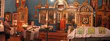
- The Roman Catholic Church of Christ's Ascension in Rundēni[1]
- The Orthodox Church of Birth of Our Lady in Vertulova
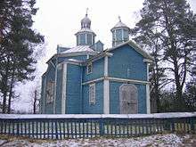
Documentary certificates of the construction of church were not kept. It is known, that in 1783 on this place stood Uniat (Greek Catholic Church) Church's temple. The precursor of present church has been constructed of clay and juniper branches in 1836, On this place in 1862 there has been begun construction of a new building of the church, ended in 1866. The church is 18 metres long, 9 metres wide and 15 metres tall. In the 19th century Vertulova's orthodox congregation was allocated 50 hectares of the land. However, in 1899-1901 about 300 parishioners, in searches of the best share, have moved to Siberia. Approximately 100 metres from the church is the Vertulova's modern orthodox cemetery, and 350 meters away, Vertulova's medieval cemetery, which is an archaeological monument of the culture, protected by the state.
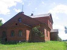
- The Orthodox Old Believers’ Church Chapel in Bližņeva
In Rundēni parish there are two Orthodox Old Believers’ Church Chapels - in Bližņeva (operating) and in Bori.
Protected archaeological and cultural monuments
| Denomination | Location |
|---|---|
| Medieval cemetery of Vertulova | Vertulova |
| Gorodoks ancient hill fort I (Gorelaya hill, Gorodoks) | Gorodoks |
| Gorodoks ancient hill fort II (Krutaya hill, Kostyolnaya hill) | Gorodoks |
| Ancient burial ground in Zirgi | Zirgi |
| Ancient burial ground and the Bull-stone in Kazici | Kazici |
| Ancient burial ground in Pešļeva | Pešļeva |
| Ancient burial ground and settlement in Pentjuši | Pentjuši |
| Ancient burial ground in Tereņeva | Between Tereņeva and Kannova |
Natural monuments
The Bull-stone in Kazici Territory of Rundēni parish is rich with stones. Near to Rundēni, in village of Kazici - on coast of inflow of Saryanka River (which runs into Daugava), there is granite Bull-stone. It is the big, ancient cult stone of the Baltic tribes. 5,3 metres at length, 3,5 metres at width and 1,8 metres in height. There is an assumption that the Bull-stone served for a designation of ancient border. On a stone are carved two crosses, and also a sign in the form of a horseshoe, as with two horns. This sign is from afar similar to a head of a deer or the bull – from here and the name the Bull-stone. In the bottom of a stone near the ground is carved a diamond-shaped sign, whose value is not clear. If to look closely, separate letters on a stone are visible. With an effort we can read a name Elizar. One part of stone as though is undermined.
Older persons speak, that if to touch a stone - that it takes away all illnesses and ailments, and gives force and energy.
There are various legends about the Bull-stone. One of them speaks that huge treasures were hidden under a stone. "Once upon a time poor smith Elizar has heard, that a treasures are hidden under a stone. He has decided to take them. Has taken a hammer, an axe and a spade and has gone to extract a treasures. When he began to dig under a stone, strong hurricane has suddenly begun. Trees have caved in up to the ground. Not clearly whence there appeared a bull and has attacked on Elizar. Elizar has not become puzzled and has struck the bull on horns. One horn has fallen. And hurricane has suddenly stopped at a same minute. The bull has disappeared. Elizar has lifted a horn, which was from pure gold. Since then Elizar became rich."
One more legend about the Bull-stone: "On the Līgo night the stone becomes red and hot, and on it the black cat sits and purrs. However there are no daredevils to check up it."
Rundēni Devil’s Pits Rundēni Devil’s Pits is a natural monument, the area - 3 hectares. Is on Height of Latgale in 3-4 kilometres on northeast from Rundēni, in 800 metres from the Rundēni-Lauderi road, in territory of the Rundēni and Lauderu parishes. Since 1997 Devil's Pits are a protected geomorphological object, unique similar type in Baltic states. There are five pits of an unknown origin; the water fills one, bushes of a raspberry - others. Occurrence of pits could be bound with possible falling of meteorite. There are also assumptions that Devil's Pits are karstic formations.
Sculptural monuments and installations
- The Hill of Crosses[2]
- Memorial complex in Sūnupļava
The memorial ensemble was created in memory of eleven heroes of different nationalities, of World War II on Height of Sūnupļava (Height 144). It is on a roadside of the Rundēni-Lauderi road. The memorial ensemble is created from greater boulders (author A. Dripe).