Routeburn River
The Routeburn River, also known as the Route Burn, is a river in New Zealand. It is a short stony river that flows for some 15 kilometres[1] into the Dart River[2] in the South Island. The Routeburn River flows alongside a section of the Routeburn Track. The upper reaches of the river are found in the Routeburn North Branch and leave the Routeburn Track around the Routeburn Flat Hut area.
| Routeburn River | |
|---|---|
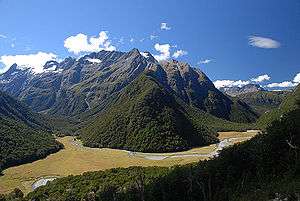 The Routeburn River winds around the Humboldt Range. | |
| Location | |
| Country | New Zealand |
| Physical characteristics | |
| Source | |
| • location | Humboldt Range |
| Mouth | |
• location | Dart River |
| Length | 15 km (9.3 mi) |
The river has two main branches of similar length, which meet some 8 kilometres from the Dart. Both of these streams have sources in the Humboldt Range. One of these streams flows due south from the slopes of the 1960-metre Nereus Peak; the other flows south then east from Lake Wilson, a small tarn, passing through Lake Harris and over the Routeburn Falls. Several smaller streams join the river from the south closer to its entry into the Dart River.[1]